You are here: Home > Network List > TA - USArray Transportable Network (new EarthScope stations) Stations List
> Station P19K Oil Pt, AK, USA > Earthquake Result Viewer
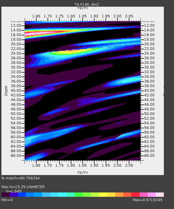
P19K Oil Pt, AK, USA - Earthquake Result Viewer
| Earthquake location: |
Vanuatu Islands |
| Earthquake latitude/longitude: |
-14.6/167.4 |
| Earthquake time(UTC): |
2017/05/09 (129) 13:52:10 GMT |
| Earthquake Depth: |
169 km |
| Earthquake Magnitude: |
6.8 mww |
| Earthquake Catalog/Contributor: |
NEIC PDE/us |
|
| Network: |
TA USArray Transportable Network (new EarthScope stations) |
| Station: |
P19K Oil Pt, AK, USA |
| Lat/Lon: |
59.65 N/153.23 W |
| Elevation: |
629 m |
|
| Distance: |
80.6 deg |
| Az: |
19.068 deg |
| Baz: |
218.525 deg |
| Ray Param: |
0.047792707 |
| Estimated Moho Depth: |
15.25 km |
| Estimated Crust Vp/Vs: |
1.64 |
| Assumed Crust Vp: |
5.989 km/s |
| Estimated Crust Vs: |
3.641 km/s |
| Estimated Crust Poisson's Ratio: |
0.21 |
|
| Radial Match: |
88.786354 % |
| Radial Bump: |
400 |
| Transverse Match: |
85.138725 % |
| Transverse Bump: |
400 |
| SOD ConfigId: |
11737051 |
| Insert Time: |
2019-04-27 08:05:52.852 +0000 |
| GWidth: |
2.5 |
| Max Bumps: |
400 |
| Tol: |
0.001 |
|

Signal To Noise
| Channel | StoN | STA | LTA |
| TA:P19K: :BHZ:20170509T14:03:33.300005Z | 31.943039 | 1.1424931E-5 | 3.5766575E-7 |
| TA:P19K: :BHN:20170509T14:03:33.300005Z | 8.841281 | 2.6005039E-6 | 2.9413204E-7 |
| TA:P19K: :BHE:20170509T14:03:33.300005Z | 5.802226 | 1.923662E-6 | 3.3153864E-7 |
| Arrivals |
| Ps | 1.7 SECOND |
| PpPs | 6.6 SECOND |
| PsPs/PpSs | 8.2 SECOND |


