You are here: Home > Network List > TA - USArray Transportable Network (new EarthScope stations) Stations List
> Station Q16K King Salmon, AK, USA > Earthquake Result Viewer
Q16K King Salmon, AK, USA - Earthquake Result Viewer
| Earthquake location: |
Vanuatu Islands |
| Earthquake latitude/longitude: |
-14.6/167.4 |
| Earthquake time(UTC): |
2017/05/09 (129) 13:52:10 GMT |
| Earthquake Depth: |
169 km |
| Earthquake Magnitude: |
6.8 mww |
| Earthquake Catalog/Contributor: |
NEIC PDE/us |
|
| Network: |
TA USArray Transportable Network (new EarthScope stations) |
| Station: |
Q16K King Salmon, AK, USA |
| Lat/Lon: |
58.68 N/156.66 W |
| Elevation: |
22 m |
|
| Distance: |
78.7 deg |
| Az: |
18.234 deg |
| Baz: |
215.44 deg |
| Ray Param: |
0.049040917 |
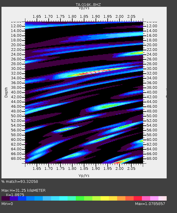
| Estimated Moho Depth: |
31.25 km |
| Estimated Crust Vp/Vs: |
1.90 |
| Assumed Crust Vp: |
6.276 km/s |
| Estimated Crust Vs: |
3.307 km/s |
| Estimated Crust Poisson's Ratio: |
0.31 |
|
| Radial Match: |
93.32058 % |
| Radial Bump: |
400 |
| Transverse Match: |
92.03703 % |
| Transverse Bump: |
400 |
| SOD ConfigId: |
11737051 |
| Insert Time: |
2019-04-27 08:05:57.758 +0000 |
| GWidth: |
2.5 |
| Max Bumps: |
400 |
| Tol: |
0.001 |
|

Signal To Noise
| Channel | StoN | STA | LTA |
| TA:Q16K: :BHZ:20170509T14:03:23.425005Z | 61.39434 | 1.1540241E-5 | 1.8796914E-7 |
| TA:Q16K: :BHN:20170509T14:03:23.425005Z | 17.45621 | 4.670549E-6 | 2.6755805E-7 |
| TA:Q16K: :BHE:20170509T14:03:23.425005Z | 7.955669 | 2.8087118E-6 | 3.5304532E-7 |
| Arrivals |
| Ps | 4.6 SECOND |
| PpPs | 14 SECOND |
| PsPs/PpSs | 19 SECOND |


