You are here: Home > Network List > TA - USArray Transportable Network (new EarthScope stations) Stations List
> Station Q24A Divide, CO, USA > Earthquake Result Viewer
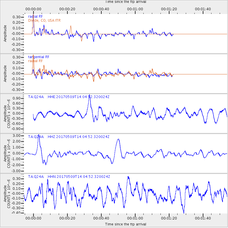
Q24A Divide, CO, USA - Earthquake Result Viewer
*The percent match for this event was below the threshold and hence no stack was calculated.
| Earthquake location: |
Vanuatu Islands |
| Earthquake latitude/longitude: |
-14.6/167.4 |
| Earthquake time(UTC): |
2017/05/09 (129) 13:52:10 GMT |
| Earthquake Depth: |
169 km |
| Earthquake Magnitude: |
6.8 mww |
| Earthquake Catalog/Contributor: |
NEIC PDE/us |
|
| Network: |
TA USArray Transportable Network (new EarthScope stations) |
| Station: |
Q24A Divide, CO, USA |
| Lat/Lon: |
38.96 N/105.15 W |
| Elevation: |
2775 m |
|
| Distance: |
97.1 deg |
| Az: |
51.708 deg |
| Baz: |
257.076 deg |
| Ray Param: |
$rayparam |
*The percent match for this event was below the threshold and hence was not used in the summary stack. |
|
| Radial Match: |
78.50019 % |
| Radial Bump: |
400 |
| Transverse Match: |
72.04926 % |
| Transverse Bump: |
400 |
| SOD ConfigId: |
11737051 |
| Insert Time: |
2019-04-27 08:06:01.957 +0000 |
| GWidth: |
2.5 |
| Max Bumps: |
400 |
| Tol: |
0.001 |
|
Signal To Noise
| Channel | StoN | STA | LTA |
| TA:Q24A: :HHZ:20170509T14:04:52.320024Z | 12.454746 | 1.3871694E-6 | 1.11376764E-7 |
| TA:Q24A: :HHN:20170509T14:04:52.320024Z | 1.2517198 | 9.569195E-8 | 7.644838E-8 |
| TA:Q24A: :HHE:20170509T14:04:52.320024Z | 4.501554 | 5.2819996E-7 | 1.1733725E-7 |
| Arrivals |
| Ps | |
| PpPs | |
| PsPs/PpSs | |


