You are here: Home > Network List > TA - USArray Transportable Network (new EarthScope stations) Stations List
> Station 231A Bronte, TX, USA > Earthquake Result Viewer
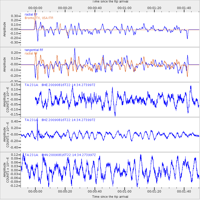
231A Bronte, TX, USA - Earthquake Result Viewer
*The percent match for this event was below the threshold and hence no stack was calculated.
| Earthquake location: |
Fiji Islands Region |
| Earthquake latitude/longitude: |
-17.9/-179.4 |
| Earthquake time(UTC): |
2009/08/16 (228) 22:03:09 GMT |
| Earthquake Depth: |
626 km |
| Earthquake Magnitude: |
5.5 MW, 4.9 MB |
| Earthquake Catalog/Contributor: |
WHDF/NEIC |
|
| Network: |
TA USArray Transportable Network (new EarthScope stations) |
| Station: |
231A Bronte, TX, USA |
| Lat/Lon: |
31.94 N/100.32 W |
| Elevation: |
574 m |
|
| Distance: |
90.4 deg |
| Az: |
56.603 deg |
| Baz: |
249.196 deg |
| Ray Param: |
$rayparam |
*The percent match for this event was below the threshold and hence was not used in the summary stack. |
|
| Radial Match: |
59.885826 % |
| Radial Bump: |
400 |
| Transverse Match: |
48.795254 % |
| Transverse Bump: |
400 |
| SOD ConfigId: |
2622 |
| Insert Time: |
2010-03-05 23:44:45.594 +0000 |
| GWidth: |
2.5 |
| Max Bumps: |
400 |
| Tol: |
0.001 |
|
Signal To Noise
| Channel | StoN | STA | LTA |
| TA:231A: :BHZ:20090816T22:14:34.273997Z | 2.0103195 | 1.248728E-7 | 6.21159E-8 |
| TA:231A: :BHN:20090816T22:14:34.273997Z | 0.93279886 | 4.768854E-8 | 5.1124143E-8 |
| TA:231A: :BHE:20090816T22:14:34.273997Z | 0.706507 | 3.2447545E-8 | 4.5926715E-8 |
| Arrivals |
| Ps | |
| PpPs | |
| PsPs/PpSs | |


