You are here: Home > Network List > TA - USArray Transportable Network (new EarthScope stations) Stations List
> Station S32K Killisnoo, AK, USA > Earthquake Result Viewer
S32K Killisnoo, AK, USA - Earthquake Result Viewer
| Earthquake location: |
Vanuatu Islands |
| Earthquake latitude/longitude: |
-14.6/167.4 |
| Earthquake time(UTC): |
2017/05/09 (129) 13:52:10 GMT |
| Earthquake Depth: |
169 km |
| Earthquake Magnitude: |
6.8 mww |
| Earthquake Catalog/Contributor: |
NEIC PDE/us |
|
| Network: |
TA USArray Transportable Network (new EarthScope stations) |
| Station: |
S32K Killisnoo, AK, USA |
| Lat/Lon: |
57.47 N/134.58 W |
| Elevation: |
26 m |
|
| Distance: |
86.2 deg |
| Az: |
27.353 deg |
| Baz: |
235.412 deg |
| Ray Param: |
0.043826863 |
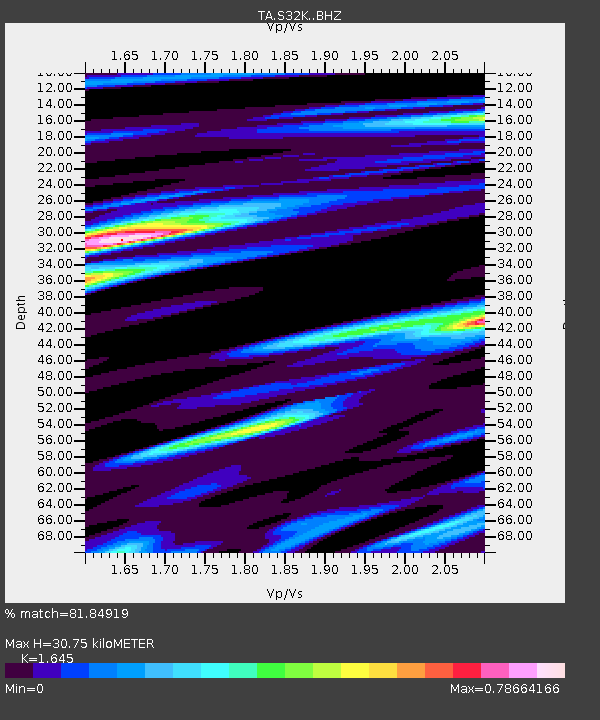
| Estimated Moho Depth: |
30.75 km |
| Estimated Crust Vp/Vs: |
1.64 |
| Assumed Crust Vp: |
6.472 km/s |
| Estimated Crust Vs: |
3.934 km/s |
| Estimated Crust Poisson's Ratio: |
0.21 |
|
| Radial Match: |
81.84919 % |
| Radial Bump: |
396 |
| Transverse Match: |
41.534645 % |
| Transverse Bump: |
400 |
| SOD ConfigId: |
11737051 |
| Insert Time: |
2019-04-27 08:06:11.259 +0000 |
| GWidth: |
2.5 |
| Max Bumps: |
400 |
| Tol: |
0.001 |
|

Signal To Noise
| Channel | StoN | STA | LTA |
| TA:S32K: :BHZ:20170509T14:04:02.075029Z | 12.318831 | 4.152627E-6 | 3.3709583E-7 |
| TA:S32K: :BHN:20170509T14:04:02.075029Z | 2.2517066 | 7.794038E-7 | 3.4613916E-7 |
| TA:S32K: :BHE:20170509T14:04:02.075029Z | 2.308752 | 1.2069404E-6 | 5.2276744E-7 |
| Arrivals |
| Ps | 3.1 SECOND |
| PpPs | 12 SECOND |
| PsPs/PpSs | 15 SECOND |


