You are here: Home > Network List > TA - USArray Transportable Network (new EarthScope stations) Stations List
> Station TPFO Pinon Flats, CA, USA > Earthquake Result Viewer
TPFO Pinon Flats, CA, USA - Earthquake Result Viewer
| Earthquake location: |
Vanuatu Islands |
| Earthquake latitude/longitude: |
-14.6/167.4 |
| Earthquake time(UTC): |
2017/05/09 (129) 13:52:10 GMT |
| Earthquake Depth: |
169 km |
| Earthquake Magnitude: |
6.8 mww |
| Earthquake Catalog/Contributor: |
NEIC PDE/us |
|
| Network: |
TA USArray Transportable Network (new EarthScope stations) |
| Station: |
TPFO Pinon Flats, CA, USA |
| Lat/Lon: |
33.61 N/116.45 W |
| Elevation: |
1275 m |
|
| Distance: |
86.8 deg |
| Az: |
54.254 deg |
| Baz: |
250.305 deg |
| Ray Param: |
0.04337421 |
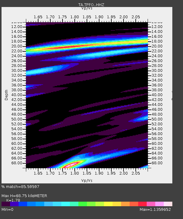
| Estimated Moho Depth: |
68.75 km |
| Estimated Crust Vp/Vs: |
1.78 |
| Assumed Crust Vp: |
6.264 km/s |
| Estimated Crust Vs: |
3.519 km/s |
| Estimated Crust Poisson's Ratio: |
0.27 |
|
| Radial Match: |
85.59597 % |
| Radial Bump: |
356 |
| Transverse Match: |
66.62531 % |
| Transverse Bump: |
400 |
| SOD ConfigId: |
11737051 |
| Insert Time: |
2019-04-27 08:06:17.419 +0000 |
| GWidth: |
2.5 |
| Max Bumps: |
400 |
| Tol: |
0.001 |
|
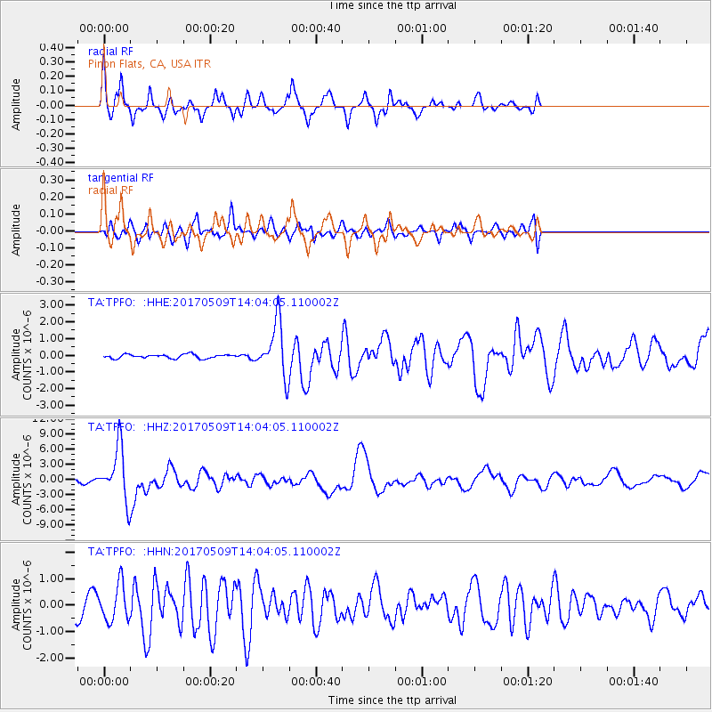
Signal To Noise
| Channel | StoN | STA | LTA |
| TA:TPFO: :HHZ:20170509T14:04:05.110002Z | 12.314417 | 5.242925E-6 | 4.2575508E-7 |
| TA:TPFO: :HHN:20170509T14:04:05.110002Z | 1.3089085 | 6.9799114E-7 | 5.33262E-7 |
| TA:TPFO: :HHE:20170509T14:04:05.110002Z | 14.142647 | 1.6262015E-6 | 1.1498565E-7 |
| Arrivals |
| Ps | 8.7 SECOND |
| PpPs | 30 SECOND |
| PsPs/PpSs | 39 SECOND |


