You are here: Home > Network List > TM - Thai Seismic Monitoring Network Stations List
> Station NAYO NAYO staion > Earthquake Result Viewer
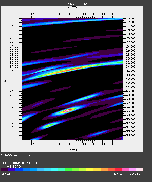
NAYO NAYO staion - Earthquake Result Viewer
| Earthquake location: |
Vanuatu Islands |
| Earthquake latitude/longitude: |
-14.6/167.4 |
| Earthquake time(UTC): |
2017/05/09 (129) 13:52:10 GMT |
| Earthquake Depth: |
169 km |
| Earthquake Magnitude: |
6.8 mww |
| Earthquake Catalog/Contributor: |
NEIC PDE/us |
|
| Network: |
TM Thai Seismic Monitoring Network |
| Station: |
NAYO NAYO staion |
| Lat/Lon: |
14.32 N/101.32 E |
| Elevation: |
106 m |
|
| Distance: |
71.4 deg |
| Az: |
290.793 deg |
| Baz: |
110.981 deg |
| Ray Param: |
0.05391213 |
| Estimated Moho Depth: |
55.5 km |
| Estimated Crust Vp/Vs: |
1.83 |
| Assumed Crust Vp: |
6.498 km/s |
| Estimated Crust Vs: |
3.555 km/s |
| Estimated Crust Poisson's Ratio: |
0.29 |
|
| Radial Match: |
80.3907 % |
| Radial Bump: |
352 |
| Transverse Match: |
73.09554 % |
| Transverse Bump: |
400 |
| SOD ConfigId: |
11737051 |
| Insert Time: |
2019-04-27 08:07:17.762 +0000 |
| GWidth: |
2.5 |
| Max Bumps: |
400 |
| Tol: |
0.001 |
|

Signal To Noise
| Channel | StoN | STA | LTA |
| TM:NAYO: :BHZ:20170509T14:02:41.599993Z | 4.1015863 | 8.906224E-5 | 2.1714097E-5 |
| TM:NAYO: :BHN:20170509T14:02:41.599993Z | 11.20938 | 1.0509309E-5 | 9.375459E-7 |
| TM:NAYO: :BHE:20170509T14:02:41.599993Z | 29.688955 | 2.7194237E-5 | 9.159715E-7 |
| Arrivals |
| Ps | 7.3 SECOND |
| PpPs | 23 SECOND |
| PsPs/PpSs | 31 SECOND |


