You are here: Home > Network List > UO - University of Oregon Regional Network Stations List
> Station FHAC Terrebonne, OR, USA > Earthquake Result Viewer
FHAC Terrebonne, OR, USA - Earthquake Result Viewer
| Earthquake location: |
Vanuatu Islands |
| Earthquake latitude/longitude: |
-14.6/167.4 |
| Earthquake time(UTC): |
2017/05/09 (129) 13:52:10 GMT |
| Earthquake Depth: |
169 km |
| Earthquake Magnitude: |
6.8 mww |
| Earthquake Catalog/Contributor: |
NEIC PDE/us |
|
| Network: |
UO University of Oregon Regional Network |
| Station: |
FHAC Terrebonne, OR, USA |
| Lat/Lon: |
44.34 N/121.34 W |
| Elevation: |
811 m |
|
| Distance: |
87.2 deg |
| Az: |
42.877 deg |
| Baz: |
246.639 deg |
| Ray Param: |
0.04309928 |
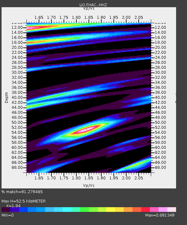
| Estimated Moho Depth: |
52.5 km |
| Estimated Crust Vp/Vs: |
1.84 |
| Assumed Crust Vp: |
6.597 km/s |
| Estimated Crust Vs: |
3.586 km/s |
| Estimated Crust Poisson's Ratio: |
0.29 |
|
| Radial Match: |
91.279465 % |
| Radial Bump: |
400 |
| Transverse Match: |
79.18599 % |
| Transverse Bump: |
400 |
| SOD ConfigId: |
11737051 |
| Insert Time: |
2019-04-27 08:07:27.456 +0000 |
| GWidth: |
2.5 |
| Max Bumps: |
400 |
| Tol: |
0.001 |
|

Signal To Noise
| Channel | StoN | STA | LTA |
| UO:FHAC: :HHZ:20170509T14:04:06.948015Z | 27.073215 | 7.3358347E-6 | 2.7096283E-7 |
| UO:FHAC: :HHN:20170509T14:04:06.948015Z | 2.9259331 | 1.0647474E-6 | 3.6390009E-7 |
| UO:FHAC: :HHE:20170509T14:04:06.948015Z | 8.899951 | 1.8166718E-6 | 2.0412155E-7 |
| Arrivals |
| Ps | 6.8 SECOND |
| PpPs | 22 SECOND |
| PsPs/PpSs | 29 SECOND |


