You are here: Home > Network List > UO - University of Oregon Regional Network Stations List
> Station MINN McMinnville, OR, USA > Earthquake Result Viewer
MINN McMinnville, OR, USA - Earthquake Result Viewer
| Earthquake location: |
Vanuatu Islands |
| Earthquake latitude/longitude: |
-14.6/167.4 |
| Earthquake time(UTC): |
2017/05/09 (129) 13:52:10 GMT |
| Earthquake Depth: |
169 km |
| Earthquake Magnitude: |
6.8 mww |
| Earthquake Catalog/Contributor: |
NEIC PDE/us |
|
| Network: |
UO University of Oregon Regional Network |
| Station: |
MINN McMinnville, OR, USA |
| Lat/Lon: |
45.21 N/123.26 W |
| Elevation: |
222 m |
|
| Distance: |
86.3 deg |
| Az: |
41.519 deg |
| Baz: |
245.211 deg |
| Ray Param: |
0.043742638 |
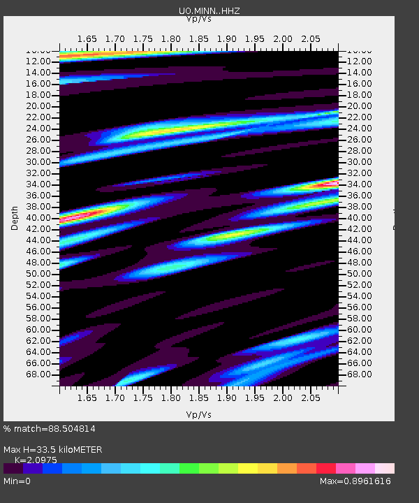
| Estimated Moho Depth: |
33.5 km |
| Estimated Crust Vp/Vs: |
2.10 |
| Assumed Crust Vp: |
6.566 km/s |
| Estimated Crust Vs: |
3.13 km/s |
| Estimated Crust Poisson's Ratio: |
0.35 |
|
| Radial Match: |
88.504814 % |
| Radial Bump: |
400 |
| Transverse Match: |
85.98295 % |
| Transverse Bump: |
400 |
| SOD ConfigId: |
11737051 |
| Insert Time: |
2019-04-27 08:07:32.806 +0000 |
| GWidth: |
2.5 |
| Max Bumps: |
400 |
| Tol: |
0.001 |
|

Signal To Noise
| Channel | StoN | STA | LTA |
| UO:MINN: :HHZ:20170509T14:04:02.628008Z | 13.458729 | 6.0202474E-6 | 4.4731172E-7 |
| UO:MINN: :HHN:20170509T14:04:02.628008Z | 3.4951007 | 1.0613828E-6 | 3.036773E-7 |
| UO:MINN: :HHE:20170509T14:04:02.628008Z | 3.7798824 | 1.6748728E-6 | 4.431018E-7 |
| Arrivals |
| Ps | 5.7 SECOND |
| PpPs | 15 SECOND |
| PsPs/PpSs | 21 SECOND |


