You are here: Home > Network List > UO - University of Oregon Regional Network Stations List
> Station TOOM Fort Rock, OR, USA > Earthquake Result Viewer
TOOM Fort Rock, OR, USA - Earthquake Result Viewer
| Earthquake location: |
Vanuatu Islands |
| Earthquake latitude/longitude: |
-14.6/167.4 |
| Earthquake time(UTC): |
2017/05/09 (129) 13:52:10 GMT |
| Earthquake Depth: |
169 km |
| Earthquake Magnitude: |
6.8 mww |
| Earthquake Catalog/Contributor: |
NEIC PDE/us |
|
| Network: |
UO University of Oregon Regional Network |
| Station: |
TOOM Fort Rock, OR, USA |
| Lat/Lon: |
43.28 N/121.23 W |
| Elevation: |
1541 m |
|
| Distance: |
86.9 deg |
| Az: |
43.876 deg |
| Baz: |
246.763 deg |
| Ray Param: |
0.043348737 |
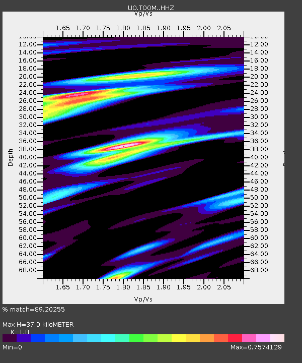
| Estimated Moho Depth: |
37.0 km |
| Estimated Crust Vp/Vs: |
1.80 |
| Assumed Crust Vp: |
6.597 km/s |
| Estimated Crust Vs: |
3.665 km/s |
| Estimated Crust Poisson's Ratio: |
0.28 |
|
| Radial Match: |
89.20255 % |
| Radial Bump: |
400 |
| Transverse Match: |
86.90588 % |
| Transverse Bump: |
400 |
| SOD ConfigId: |
11737051 |
| Insert Time: |
2019-04-27 08:07:34.913 +0000 |
| GWidth: |
2.5 |
| Max Bumps: |
400 |
| Tol: |
0.001 |
|

Signal To Noise
| Channel | StoN | STA | LTA |
| UO:TOOM: :HHZ:20170509T14:04:05.287981Z | 23.484573 | 6.0099833E-6 | 2.5591197E-7 |
| UO:TOOM: :HHN:20170509T14:04:05.287981Z | 2.5840123 | 5.0049084E-7 | 1.936875E-7 |
| UO:TOOM: :HHE:20170509T14:04:05.287981Z | 8.216294 | 1.9323722E-6 | 2.3518778E-7 |
| Arrivals |
| Ps | 4.6 SECOND |
| PpPs | 15 SECOND |
| PsPs/PpSs | 20 SECOND |


