You are here: Home > Network List > UW - Pacific Northwest Regional Seismic Network Stations List
> Station YACT Amboy, WA, USA > Earthquake Result Viewer
YACT Amboy, WA, USA - Earthquake Result Viewer
| Earthquake location: |
Vanuatu Islands |
| Earthquake latitude/longitude: |
-14.6/167.4 |
| Earthquake time(UTC): |
2017/05/09 (129) 13:52:10 GMT |
| Earthquake Depth: |
169 km |
| Earthquake Magnitude: |
6.8 mww |
| Earthquake Catalog/Contributor: |
NEIC PDE/us |
|
| Network: |
UW Pacific Northwest Regional Seismic Network |
| Station: |
YACT Amboy, WA, USA |
| Lat/Lon: |
45.93 N/122.42 W |
| Elevation: |
211 m |
|
| Distance: |
87.2 deg |
| Az: |
41.108 deg |
| Baz: |
245.789 deg |
| Ray Param: |
0.043140892 |
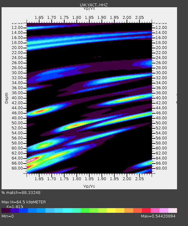
| Estimated Moho Depth: |
64.5 km |
| Estimated Crust Vp/Vs: |
1.62 |
| Assumed Crust Vp: |
6.566 km/s |
| Estimated Crust Vs: |
4.066 km/s |
| Estimated Crust Poisson's Ratio: |
0.19 |
|
| Radial Match: |
88.33248 % |
| Radial Bump: |
400 |
| Transverse Match: |
88.83463 % |
| Transverse Bump: |
400 |
| SOD ConfigId: |
11737051 |
| Insert Time: |
2019-04-27 08:08:07.570 +0000 |
| GWidth: |
2.5 |
| Max Bumps: |
400 |
| Tol: |
0.001 |
|
Signal To Noise
| Channel | StoN | STA | LTA |
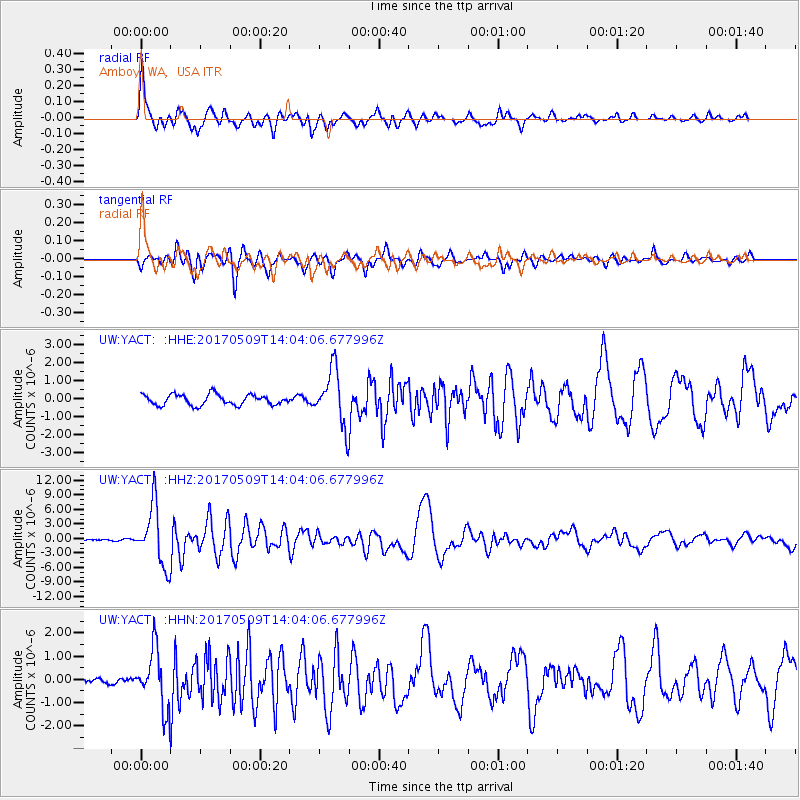
| UW:YACT: :HHZ:20170509T14:04:06.677996Z | 37.41734 | 6.1912847E-6 | 1.6546566E-7 |
| UW:YACT: :HHN:20170509T14:04:06.677996Z | 4.6439033 | 1.2785979E-6 | 2.753283E-7 |
| UW:YACT: :HHE:20170509T14:04:06.677996Z | 5.2934675 | 1.5403704E-6 | 2.9099456E-7 |
| Arrivals |
| Ps | 6.2 SECOND |
| PpPs | 25 SECOND |
| PsPs/PpSs | 31 SECOND |


