You are here: Home > Network List > TA - USArray Transportable Network (new EarthScope stations) Stations List
> Station 231A Bronte, TX, USA > Earthquake Result Viewer
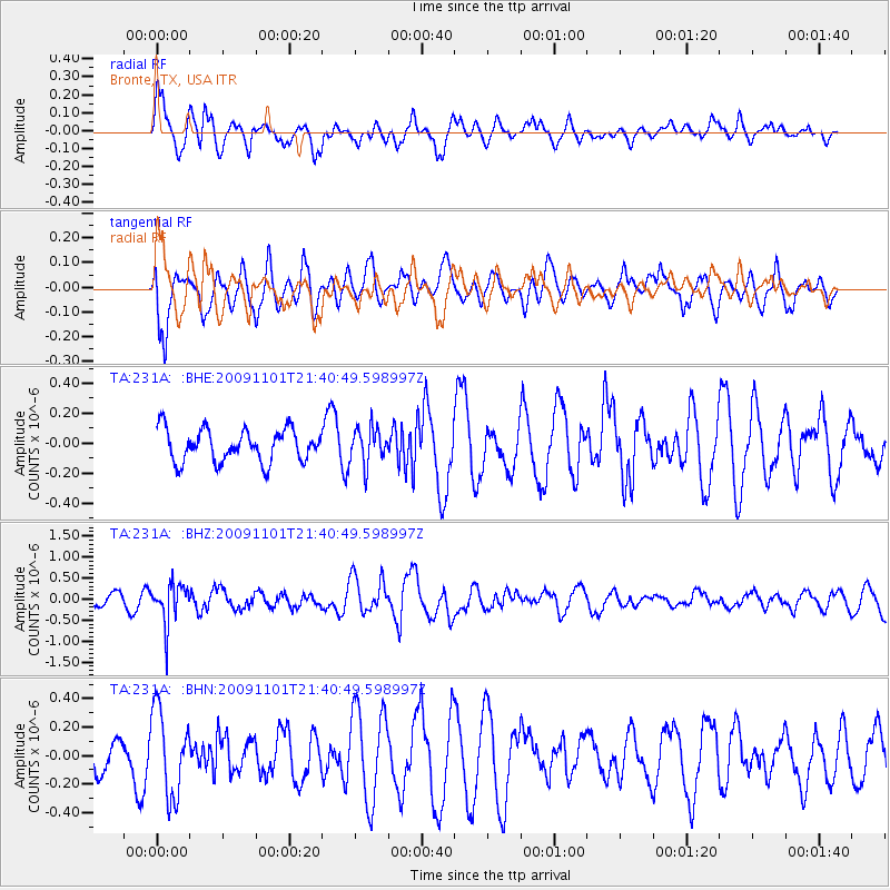
231A Bronte, TX, USA - Earthquake Result Viewer
*The percent match for this event was below the threshold and hence no stack was calculated.
| Earthquake location: |
Tonga Islands |
| Earthquake latitude/longitude: |
-15.5/-173.8 |
| Earthquake time(UTC): |
2009/11/01 (305) 21:28:58 GMT |
| Earthquake Depth: |
105 km |
| Earthquake Magnitude: |
5.8 MW, 5.4 MB, 5.8 MW |
| Earthquake Catalog/Contributor: |
WHDF/NEIC |
|
| Network: |
TA USArray Transportable Network (new EarthScope stations) |
| Station: |
231A Bronte, TX, USA |
| Lat/Lon: |
31.94 N/100.32 W |
| Elevation: |
574 m |
|
| Distance: |
84.6 deg |
| Az: |
54.941 deg |
| Baz: |
248.149 deg |
| Ray Param: |
$rayparam |
*The percent match for this event was below the threshold and hence was not used in the summary stack. |
|
| Radial Match: |
73.52489 % |
| Radial Bump: |
400 |
| Transverse Match: |
62.076942 % |
| Transverse Bump: |
400 |
| SOD ConfigId: |
2622 |
| Insert Time: |
2010-03-05 23:44:54.761 +0000 |
| GWidth: |
2.5 |
| Max Bumps: |
400 |
| Tol: |
0.001 |
|
Signal To Noise
| Channel | StoN | STA | LTA |
| TA:231A: :BHZ:20091101T21:40:49.598997Z | 4.712355 | 4.8409083E-7 | 1.02727995E-7 |
| TA:231A: :BHN:20091101T21:40:49.598997Z | 2.3425188 | 2.9653035E-7 | 1.2658612E-7 |
| TA:231A: :BHE:20091101T21:40:49.598997Z | 1.1191882 | 1.2018195E-7 | 1.0738315E-7 |
| Arrivals |
| Ps | |
| PpPs | |
| PsPs/PpSs | |


