You are here: Home > Network List > X416 - Monitoring Active Faults for Tectonic Mapping Efforts in Washington State Stations List
> Station MA06 Snohomish County, WA, USA > Earthquake Result Viewer
MA06 Snohomish County, WA, USA - Earthquake Result Viewer
| Earthquake location: |
Vanuatu Islands |
| Earthquake latitude/longitude: |
-14.6/167.4 |
| Earthquake time(UTC): |
2017/05/09 (129) 13:52:10 GMT |
| Earthquake Depth: |
169 km |
| Earthquake Magnitude: |
6.8 mww |
| Earthquake Catalog/Contributor: |
NEIC PDE/us |
|
| Network: |
X4 Monitoring Active Faults for Tectonic Mapping Efforts in Washington State |
| Station: |
MA06 Snohomish County, WA, USA |
| Lat/Lon: |
47.91 N/121.80 W |
| Elevation: |
-1.0 m |
|
| Distance: |
88.4 deg |
| Az: |
39.475 deg |
| Baz: |
246.18 deg |
| Ray Param: |
0.042259887 |
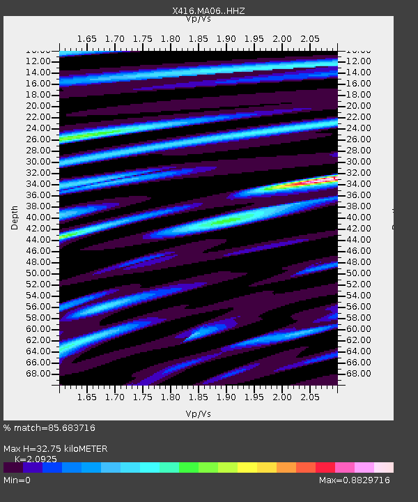
| Estimated Moho Depth: |
32.75 km |
| Estimated Crust Vp/Vs: |
2.09 |
| Assumed Crust Vp: |
6.597 km/s |
| Estimated Crust Vs: |
3.153 km/s |
| Estimated Crust Poisson's Ratio: |
0.35 |
|
| Radial Match: |
85.683716 % |
| Radial Bump: |
400 |
| Transverse Match: |
77.60184 % |
| Transverse Bump: |
400 |
| SOD ConfigId: |
11737051 |
| Insert Time: |
2019-04-27 08:08:12.783 +0000 |
| GWidth: |
2.5 |
| Max Bumps: |
400 |
| Tol: |
0.001 |
|

Signal To Noise
| Channel | StoN | STA | LTA |
| X4:MA06: :HHZ:20170509T14:04:12.344988Z | 37.744896 | 5.3817835E-6 | 1.4258309E-7 |
| X4:MA06: :HHN:20170509T14:04:12.344988Z | 4.843231 | 1.4723782E-6 | 3.0400741E-7 |
| X4:MA06: :HHE:20170509T14:04:12.344988Z | 2.1588862 | 5.8808155E-7 | 2.7240046E-7 |
| Arrivals |
| Ps | 5.5 SECOND |
| PpPs | 15 SECOND |
| PsPs/PpSs | 21 SECOND |


