You are here: Home > Network List > CI - Caltech Regional Seismic Network Stations List
> Station MWC Mount Wilson Obsv, Altadena, CA, USA > Earthquake Result Viewer
MWC Mount Wilson Obsv, Altadena, CA, USA - Earthquake Result Viewer
| Earthquake location: |
South Of Fiji Islands |
| Earthquake latitude/longitude: |
-22.1/-176.8 |
| Earthquake time(UTC): |
1997/10/14 (287) 09:53:18 GMT |
| Earthquake Depth: |
167 km |
| Earthquake Magnitude: |
6.7 MB, 7.7 UNKNOWN, 7.4 ME |
| Earthquake Catalog/Contributor: |
WHDF/NEIC |
|
| Network: |
CI Caltech Regional Seismic Network |
| Station: |
MWC Mount Wilson Obsv, Altadena, CA, USA |
| Lat/Lon: |
34.22 N/118.06 W |
| Elevation: |
1725 m |
|
| Distance: |
79.1 deg |
| Az: |
46.153 deg |
| Baz: |
233.822 deg |
| Ray Param: |
0.048803654 |
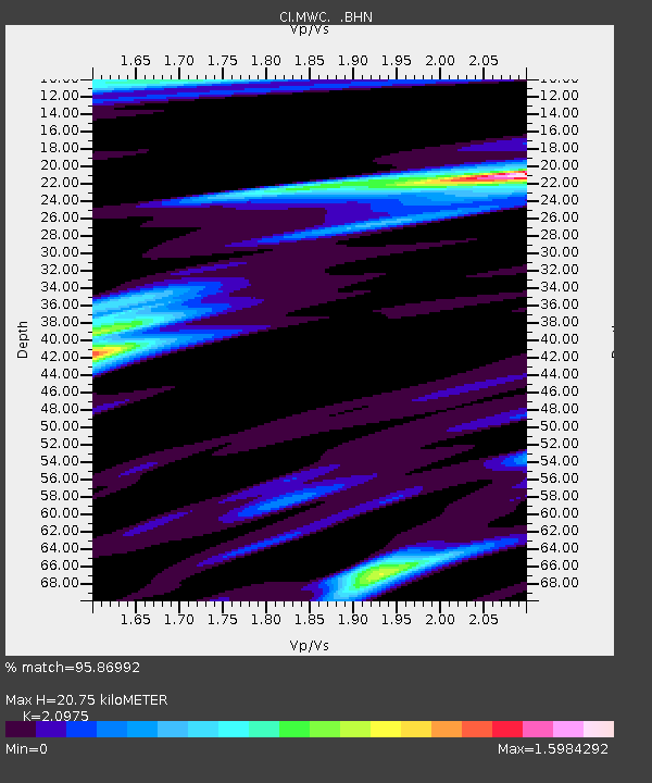
| Estimated Moho Depth: |
20.75 km |
| Estimated Crust Vp/Vs: |
2.10 |
| Assumed Crust Vp: |
6.1 km/s |
| Estimated Crust Vs: |
2.908 km/s |
| Estimated Crust Poisson's Ratio: |
0.35 |
|
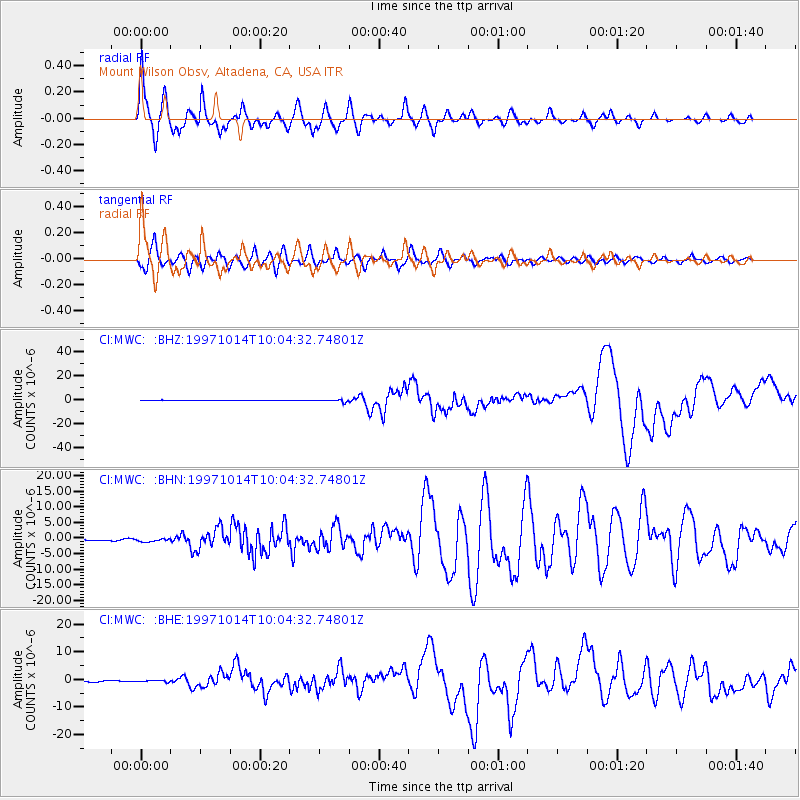
| Radial Match: |
95.86992 % |
| Radial Bump: |
400 |
| Transverse Match: |
90.25807 % |
| Transverse Bump: |
400 |
| SOD ConfigId: |
4770 |
| Insert Time: |
2010-02-26 01:10:44.153 +0000 |
| GWidth: |
2.5 |
| Max Bumps: |
400 |
| Tol: |
0.001 |
|
Signal To Noise
| Channel | StoN | STA | LTA |
| CI:MWC: :BHN:19971014T10:04:32.74801Z | 1.5427625 | 4.6770248E-7 | 3.0315908E-7 |
| CI:MWC: :BHE:19971014T10:04:32.74801Z | 1.6001899 | 3.2368015E-7 | 2.0227608E-7 |
| CI:MWC: :BHZ:19971014T10:04:32.74801Z | 3.8571239 | 9.212775E-7 | 2.388509E-7 |
| Arrivals |
| Ps | 3.8 SECOND |
| PpPs | 10 SECOND |
| PsPs/PpSs | 14 SECOND |


