You are here: Home > Network List > CI - Caltech Regional Seismic Network Stations List
> Station MWC Mount Wilson Obsv, Altadena, CA, USA > Earthquake Result Viewer
MWC Mount Wilson Obsv, Altadena, CA, USA - Earthquake Result Viewer
| Earthquake location: |
Near Coast Of Central Chile |
| Earthquake latitude/longitude: |
-30.9/-71.2 |
| Earthquake time(UTC): |
1997/10/15 (288) 01:03:33 GMT |
| Earthquake Depth: |
58 km |
| Earthquake Magnitude: |
6.8 MB, 6.8 MS, 7.3 UNKNOWN, 7.1 MW |
| Earthquake Catalog/Contributor: |
WHDF/NEIC |
|
| Network: |
CI Caltech Regional Seismic Network |
| Station: |
MWC Mount Wilson Obsv, Altadena, CA, USA |
| Lat/Lon: |
34.22 N/118.06 W |
| Elevation: |
1725 m |
|
| Distance: |
78.4 deg |
| Az: |
321.906 deg |
| Baz: |
140.223 deg |
| Ray Param: |
0.049539957 |
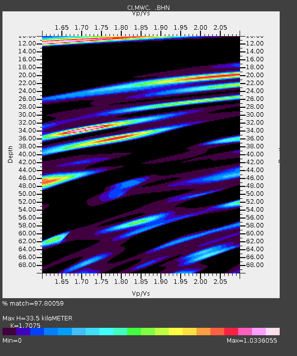
| Estimated Moho Depth: |
33.5 km |
| Estimated Crust Vp/Vs: |
1.71 |
| Assumed Crust Vp: |
6.1 km/s |
| Estimated Crust Vs: |
3.572 km/s |
| Estimated Crust Poisson's Ratio: |
0.24 |
|
| Radial Match: |
97.80059 % |
| Radial Bump: |
400 |
| Transverse Match: |
95.07752 % |
| Transverse Bump: |
400 |
| SOD ConfigId: |
4770 |
| Insert Time: |
2010-02-26 01:10:45.500 +0000 |
| GWidth: |
2.5 |
| Max Bumps: |
400 |
| Tol: |
0.001 |
|

Signal To Noise
| Channel | StoN | STA | LTA |
| CI:MWC: :BHN:19971015T01:14:56.897009Z | 0.8987926 | 2.839086E-7 | 3.1587777E-7 |
| CI:MWC: :BHE:19971015T01:14:56.897009Z | 0.7824043 | 1.7732306E-7 | 2.2663866E-7 |
| CI:MWC: :BHZ:19971015T01:14:56.897009Z | 3.0824041 | 5.2063376E-7 | 1.689051E-7 |
| Arrivals |
| Ps | 4.0 SECOND |
| PpPs | 14 SECOND |
| PsPs/PpSs | 18 SECOND |


