You are here: Home > Network List > GM - US Geological Survey Networks Stations List
> Station IWM01 Jericho 2M Well Monitoring Station > Earthquake Result Viewer
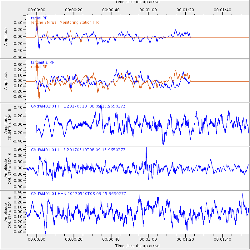
IWM01 Jericho 2M Well Monitoring Station - Earthquake Result Viewer
*The percent match for this event was below the threshold and hence no stack was calculated.
| Earthquake location: |
Andreanof Islands, Aleutian Is. |
| Earthquake latitude/longitude: |
51.4/-178.5 |
| Earthquake time(UTC): |
2017/05/10 (130) 07:59:55 GMT |
| Earthquake Depth: |
1.0 km |
| Earthquake Magnitude: |
6.0 Mi |
| Earthquake Catalog/Contributor: |
NEIC PDE/at |
|
| Network: |
GM US Geological Survey Networks |
| Station: |
IWM01 Jericho 2M Well Monitoring Station |
| Lat/Lon: |
36.73 N/96.53 W |
| Elevation: |
328 m |
|
| Distance: |
57.7 deg |
| Az: |
70.304 deg |
| Baz: |
312.821 deg |
| Ray Param: |
$rayparam |
*The percent match for this event was below the threshold and hence was not used in the summary stack. |
|
| Radial Match: |
50.186153 % |
| Radial Bump: |
378 |
| Transverse Match: |
50.69768 % |
| Transverse Bump: |
400 |
| SOD ConfigId: |
11737051 |
| Insert Time: |
2019-04-27 08:14:06.338 +0000 |
| GWidth: |
2.5 |
| Max Bumps: |
400 |
| Tol: |
0.001 |
|
Signal To Noise
| Channel | StoN | STA | LTA |
| GM:IWM01:01:HHZ:20170510T08:09:15.965027Z | 3.7836957 | 3.1488463E-7 | 8.322145E-8 |
| GM:IWM01:01:HHN:20170510T08:09:15.965027Z | 1.4011005 | 1.4856592E-7 | 1.0603516E-7 |
| GM:IWM01:01:HHE:20170510T08:09:15.965027Z | 1.5754309 | 2.0154316E-7 | 1.2792891E-7 |
| Arrivals |
| Ps | |
| PpPs | |
| PsPs/PpSs | |


