You are here: Home > Network List > TA - USArray Transportable Network (new EarthScope stations) Stations List
> Station 331A San Angelo, TX, USA > Earthquake Result Viewer
331A San Angelo, TX, USA - Earthquake Result Viewer
| Earthquake location: |
Tonga Islands Region |
| Earthquake latitude/longitude: |
-23.0/-174.7 |
| Earthquake time(UTC): |
2009/03/19 (078) 18:17:40 GMT |
| Earthquake Depth: |
34 km |
| Earthquake Magnitude: |
7.0 MB, 7.6 MS, 7.6 MW, 7.6 MW |
| Earthquake Catalog/Contributor: |
WHDF/NEIC |
|
| Network: |
TA USArray Transportable Network (new EarthScope stations) |
| Station: |
331A San Angelo, TX, USA |
| Lat/Lon: |
31.31 N/100.43 W |
| Elevation: |
615 m |
|
| Distance: |
89.3 deg |
| Az: |
55.466 deg |
| Baz: |
242.443 deg |
| Ray Param: |
0.04193908 |
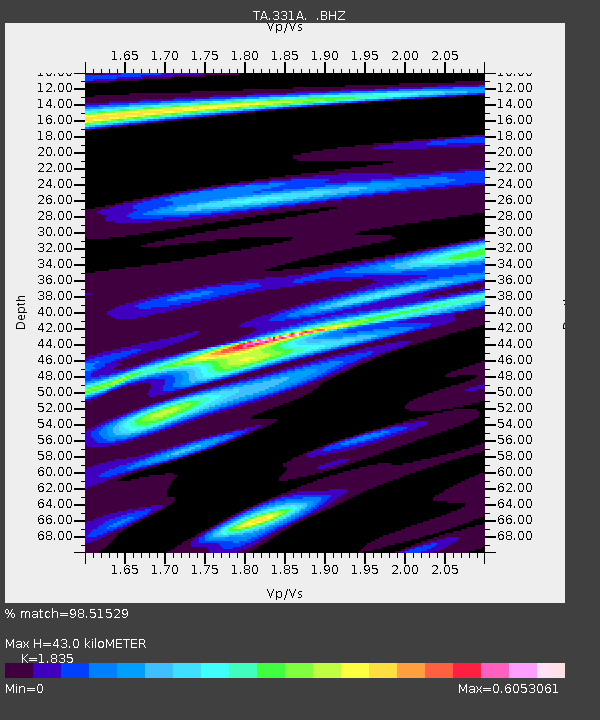
| Estimated Moho Depth: |
43.0 km |
| Estimated Crust Vp/Vs: |
1.84 |
| Assumed Crust Vp: |
6.38 km/s |
| Estimated Crust Vs: |
3.477 km/s |
| Estimated Crust Poisson's Ratio: |
0.29 |
|
| Radial Match: |
98.51529 % |
| Radial Bump: |
340 |
| Transverse Match: |
89.590775 % |
| Transverse Bump: |
400 |
| SOD ConfigId: |
2658 |
| Insert Time: |
2010-03-05 23:45:39.517 +0000 |
| GWidth: |
2.5 |
| Max Bumps: |
400 |
| Tol: |
0.001 |
|
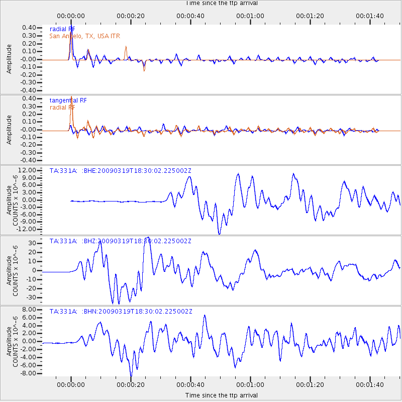
Signal To Noise
| Channel | StoN | STA | LTA |
| TA:331A: :BHZ:20090319T18:30:02.225002Z | 18.353388 | 5.5650667E-6 | 3.032174E-7 |
| TA:331A: :BHN:20090319T18:30:02.225002Z | 10.162373 | 7.039327E-7 | 6.9268545E-8 |
| TA:331A: :BHE:20090319T18:30:02.225002Z | 10.6617155 | 1.6520993E-6 | 1.5495624E-7 |
| Arrivals |
| Ps | 5.7 SECOND |
| PpPs | 19 SECOND |
| PsPs/PpSs | 24 SECOND |


