You are here: Home > Network List > TA - USArray Transportable Network (new EarthScope stations) Stations List
> Station 331A San Angelo, TX, USA > Earthquake Result Viewer
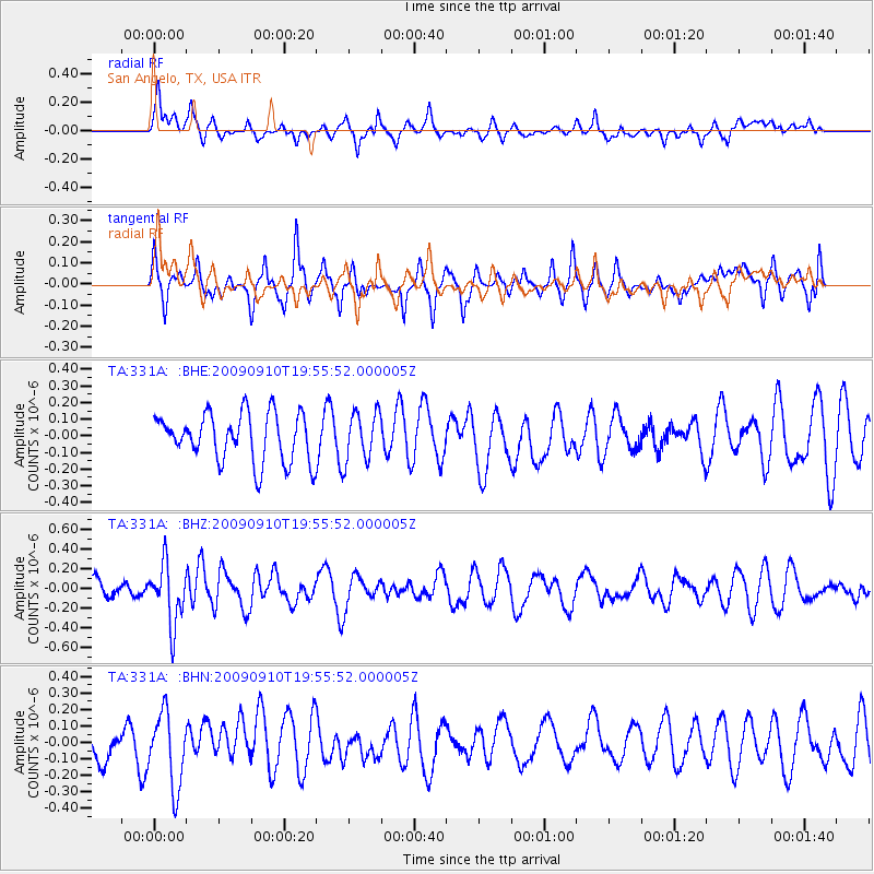
331A San Angelo, TX, USA - Earthquake Result Viewer
*The percent match for this event was below the threshold and hence no stack was calculated.
| Earthquake location: |
Easter Island Region |
| Earthquake latitude/longitude: |
-29.9/-111.8 |
| Earthquake time(UTC): |
2009/09/10 (253) 19:46:03 GMT |
| Earthquake Depth: |
10 km |
| Earthquake Magnitude: |
5.5 MW, 5.4 MB |
| Earthquake Catalog/Contributor: |
WHDF/NEIC |
|
| Network: |
TA USArray Transportable Network (new EarthScope stations) |
| Station: |
331A San Angelo, TX, USA |
| Lat/Lon: |
31.31 N/100.43 W |
| Elevation: |
615 m |
|
| Distance: |
61.9 deg |
| Az: |
11.059 deg |
| Baz: |
191.219 deg |
| Ray Param: |
$rayparam |
*The percent match for this event was below the threshold and hence was not used in the summary stack. |
|
| Radial Match: |
51.914303 % |
| Radial Bump: |
400 |
| Transverse Match: |
55.102356 % |
| Transverse Bump: |
400 |
| SOD ConfigId: |
2622 |
| Insert Time: |
2010-03-05 23:46:04.836 +0000 |
| GWidth: |
2.5 |
| Max Bumps: |
400 |
| Tol: |
0.001 |
|
Signal To Noise
| Channel | StoN | STA | LTA |
| TA:331A: :BHZ:20090910T19:55:52.000005Z | 2.8274746 | 3.0521585E-7 | 1.0794645E-7 |
| TA:331A: :BHN:20090910T19:55:52.000005Z | 2.888744 | 2.2178824E-7 | 7.67767E-8 |
| TA:331A: :BHE:20090910T19:55:52.000005Z | 1.0236498 | 1.477776E-7 | 1.4436343E-7 |
| Arrivals |
| Ps | |
| PpPs | |
| PsPs/PpSs | |


