You are here: Home > Network List > TA - USArray Transportable Network (new EarthScope stations) Stations List
> Station 331A San Angelo, TX, USA > Earthquake Result Viewer
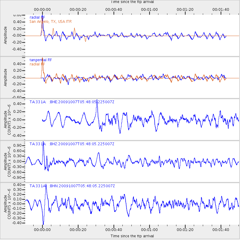
331A San Angelo, TX, USA - Earthquake Result Viewer
*The percent match for this event was below the threshold and hence no stack was calculated.
| Earthquake location: |
Rat Islands, Aleutian Islands |
| Earthquake latitude/longitude: |
52.2/178.1 |
| Earthquake time(UTC): |
2009/10/07 (280) 05:38:37 GMT |
| Earthquake Depth: |
138 km |
| Earthquake Magnitude: |
5.6 MB, 5.6 MW, 5.6 MW |
| Earthquake Catalog/Contributor: |
WHDF/NEIC |
|
| Network: |
TA USArray Transportable Network (new EarthScope stations) |
| Station: |
331A San Angelo, TX, USA |
| Lat/Lon: |
31.31 N/100.43 W |
| Elevation: |
615 m |
|
| Distance: |
61.0 deg |
| Az: |
75.486 deg |
| Baz: |
315.829 deg |
| Ray Param: |
$rayparam |
*The percent match for this event was below the threshold and hence was not used in the summary stack. |
|
| Radial Match: |
57.218616 % |
| Radial Bump: |
346 |
| Transverse Match: |
61.734215 % |
| Transverse Bump: |
348 |
| SOD ConfigId: |
2622 |
| Insert Time: |
2010-03-05 23:46:09.378 +0000 |
| GWidth: |
2.5 |
| Max Bumps: |
400 |
| Tol: |
0.001 |
|
Signal To Noise
| Channel | StoN | STA | LTA |
| TA:331A: :BHZ:20091007T05:48:05.225007Z | 3.458661 | 4.0370963E-7 | 1.1672426E-7 |
| TA:331A: :BHN:20091007T05:48:05.225007Z | 2.987165 | 2.1617308E-7 | 7.236731E-8 |
| TA:331A: :BHE:20091007T05:48:05.225007Z | 2.1320183 | 2.0774809E-7 | 9.744198E-8 |
| Arrivals |
| Ps | |
| PpPs | |
| PsPs/PpSs | |


