You are here: Home > Network List > TA - USArray Transportable Network (new EarthScope stations) Stations List
> Station 331A San Angelo, TX, USA > Earthquake Result Viewer
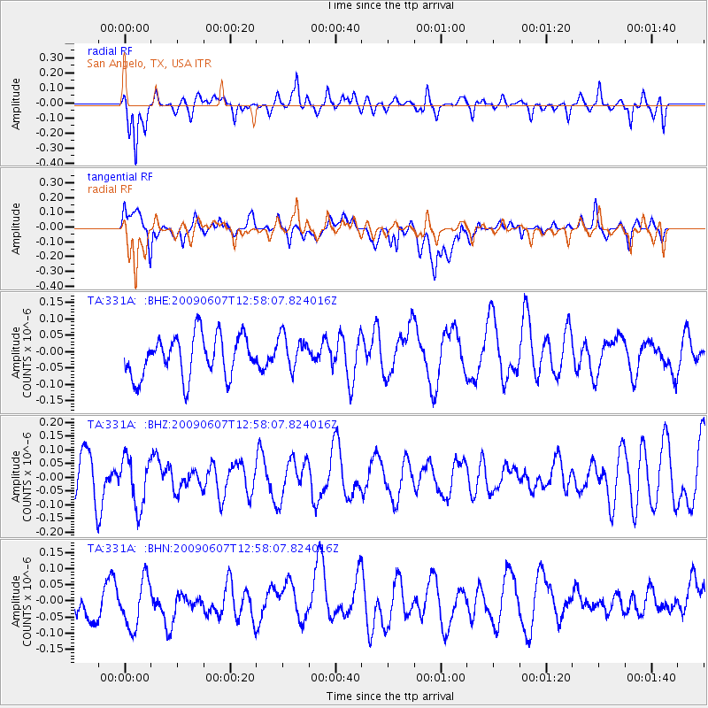
331A San Angelo, TX, USA - Earthquake Result Viewer
*The percent match for this event was below the threshold and hence no stack was calculated.
| Earthquake location: |
South Of Fiji Islands |
| Earthquake latitude/longitude: |
-22.0/-179.6 |
| Earthquake time(UTC): |
2009/06/07 (158) 12:46:30 GMT |
| Earthquake Depth: |
590 km |
| Earthquake Magnitude: |
5.5 MW, 5.1 MB |
| Earthquake Catalog/Contributor: |
WHDF/NEIC |
|
| Network: |
TA USArray Transportable Network (new EarthScope stations) |
| Station: |
331A San Angelo, TX, USA |
| Lat/Lon: |
31.31 N/100.43 W |
| Elevation: |
615 m |
|
| Distance: |
92.5 deg |
| Az: |
57.292 deg |
| Baz: |
245.799 deg |
| Ray Param: |
$rayparam |
*The percent match for this event was below the threshold and hence was not used in the summary stack. |
|
| Radial Match: |
58.65835 % |
| Radial Bump: |
385 |
| Transverse Match: |
40.12875 % |
| Transverse Bump: |
400 |
| SOD ConfigId: |
2648 |
| Insert Time: |
2010-03-05 23:46:18.922 +0000 |
| GWidth: |
2.5 |
| Max Bumps: |
400 |
| Tol: |
0.001 |
|
Signal To Noise
| Channel | StoN | STA | LTA |
| TA:331A: :BHZ:20090607T12:58:07.824016Z | 1.3611382 | 9.028265E-8 | 6.632879E-8 |
| TA:331A: :BHN:20090607T12:58:07.824016Z | 1.3406818 | 7.8402614E-8 | 5.847966E-8 |
| TA:331A: :BHE:20090607T12:58:07.824016Z | 0.83231366 | 5.250798E-8 | 6.3086766E-8 |
| Arrivals |
| Ps | |
| PpPs | |
| PsPs/PpSs | |


