You are here: Home > Network List > TA - USArray Transportable Network (new EarthScope stations) Stations List
> Station C36M Paulatuk, NT, CAN > Earthquake Result Viewer
C36M Paulatuk, NT, CAN - Earthquake Result Viewer
| Earthquake location: |
Andreanof Islands, Aleutian Is. |
| Earthquake latitude/longitude: |
51.4/-178.5 |
| Earthquake time(UTC): |
2017/05/10 (130) 07:59:55 GMT |
| Earthquake Depth: |
1.0 km |
| Earthquake Magnitude: |
6.0 Mi |
| Earthquake Catalog/Contributor: |
NEIC PDE/at |
|
| Network: |
TA USArray Transportable Network (new EarthScope stations) |
| Station: |
C36M Paulatuk, NT, CAN |
| Lat/Lon: |
69.35 N/124.07 W |
| Elevation: |
10 m |
|
| Distance: |
30.9 deg |
| Az: |
34.221 deg |
| Baz: |
262.831 deg |
| Ray Param: |
0.07923295 |
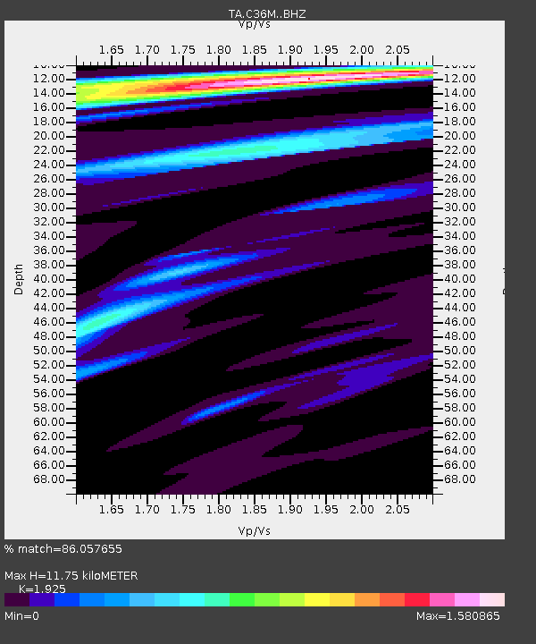
| Estimated Moho Depth: |
11.75 km |
| Estimated Crust Vp/Vs: |
1.92 |
| Assumed Crust Vp: |
6.459 km/s |
| Estimated Crust Vs: |
3.356 km/s |
| Estimated Crust Poisson's Ratio: |
0.32 |
|
| Radial Match: |
86.057655 % |
| Radial Bump: |
372 |
| Transverse Match: |
60.79142 % |
| Transverse Bump: |
301 |
| SOD ConfigId: |
11737051 |
| Insert Time: |
2019-04-27 08:19:52.831 +0000 |
| GWidth: |
2.5 |
| Max Bumps: |
400 |
| Tol: |
0.001 |
|

Signal To Noise
| Channel | StoN | STA | LTA |
| TA:C36M: :BHZ:20170510T08:05:41.174988Z | 5.014776 | 3.997021E-7 | 7.970487E-8 |
| TA:C36M: :BHN:20170510T08:05:41.174988Z | 2.857364 | 1.9816598E-7 | 6.935272E-8 |
| TA:C36M: :BHE:20170510T08:05:41.174988Z | 2.7489343 | 1.8809932E-7 | 6.8426274E-8 |
| Arrivals |
| Ps | 1.8 SECOND |
| PpPs | 4.9 SECOND |
| PsPs/PpSs | 6.8 SECOND |


