You are here: Home > Network List > US - United States National Seismic Network Stations List
> Station MNTX Cornudas Mountains, Texas, USA > Earthquake Result Viewer
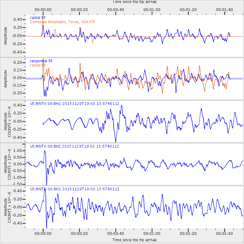
MNTX Cornudas Mountains, Texas, USA - Earthquake Result Viewer
*The percent match for this event was below the threshold and hence no stack was calculated.
| Earthquake location: |
Jujuy Province, Argentina |
| Earthquake latitude/longitude: |
-23.5/-64.6 |
| Earthquake time(UTC): |
2015/11/29 (333) 18:52:49 GMT |
| Earthquake Depth: |
9.6 km |
| Earthquake Magnitude: |
5.9 MWP |
| Earthquake Catalog/Contributor: |
NEIC PDE/NEIC COMCAT |
|
| Network: |
US United States National Seismic Network |
| Station: |
MNTX Cornudas Mountains, Texas, USA |
| Lat/Lon: |
31.70 N/105.38 W |
| Elevation: |
404 m |
|
| Distance: |
67.4 deg |
| Az: |
322.905 deg |
| Baz: |
139.505 deg |
| Ray Param: |
$rayparam |
*The percent match for this event was below the threshold and hence was not used in the summary stack. |
|
| Radial Match: |
66.32623 % |
| Radial Bump: |
400 |
| Transverse Match: |
76.34541 % |
| Transverse Bump: |
400 |
| SOD ConfigId: |
1259291 |
| Insert Time: |
2015-12-13 21:32:20.388 +0000 |
| GWidth: |
2.5 |
| Max Bumps: |
400 |
| Tol: |
0.001 |
|
Signal To Noise
| Channel | StoN | STA | LTA |
| US:MNTX:00:BHZ:20151129T19:03:13.674011Z | 4.104397 | 5.827175E-7 | 1.4197396E-7 |
| US:MNTX:00:BH1:20151129T19:03:13.674011Z | 2.4806128 | 2.5502916E-7 | 1.0280895E-7 |
| US:MNTX:00:BH2:20151129T19:03:13.674011Z | 1.7679808 | 1.2931844E-7 | 7.3144705E-8 |
| Arrivals |
| Ps | |
| PpPs | |
| PsPs/PpSs | |


