You are here: Home > Network List > TA - USArray Transportable Network (new EarthScope stations) Stations List
> Station 332A Millersview, TX, USA > Earthquake Result Viewer
332A Millersview, TX, USA - Earthquake Result Viewer
| Earthquake location: |
Southeast Of Honshu, Japan |
| Earthquake latitude/longitude: |
32.8/140.4 |
| Earthquake time(UTC): |
2009/08/12 (224) 22:48:51 GMT |
| Earthquake Depth: |
53 km |
| Earthquake Magnitude: |
6.2 MB, 6.6 MW, 6.6 MW |
| Earthquake Catalog/Contributor: |
WHDF/NEIC |
|
| Network: |
TA USArray Transportable Network (new EarthScope stations) |
| Station: |
332A Millersview, TX, USA |
| Lat/Lon: |
31.38 N/99.74 W |
| Elevation: |
513 m |
|
| Distance: |
94.5 deg |
| Az: |
48.075 deg |
| Baz: |
312.903 deg |
| Ray Param: |
0.040991623 |
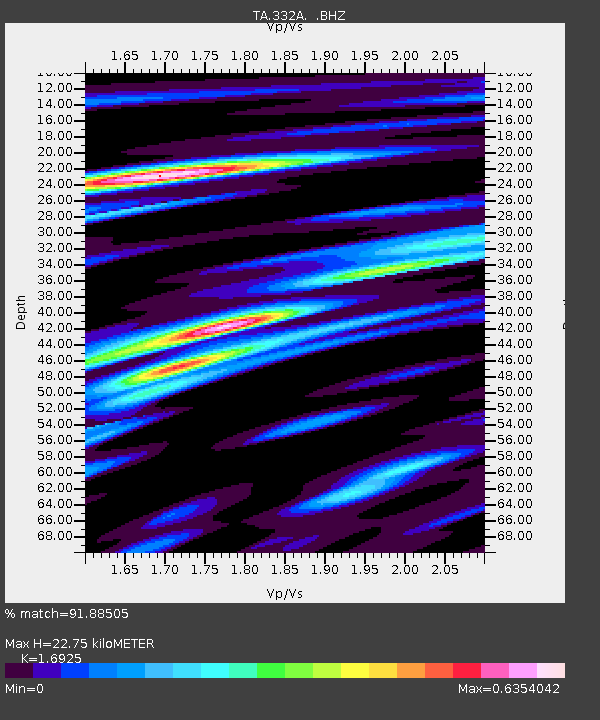
| Estimated Moho Depth: |
22.75 km |
| Estimated Crust Vp/Vs: |
1.69 |
| Assumed Crust Vp: |
6.498 km/s |
| Estimated Crust Vs: |
3.839 km/s |
| Estimated Crust Poisson's Ratio: |
0.23 |
|
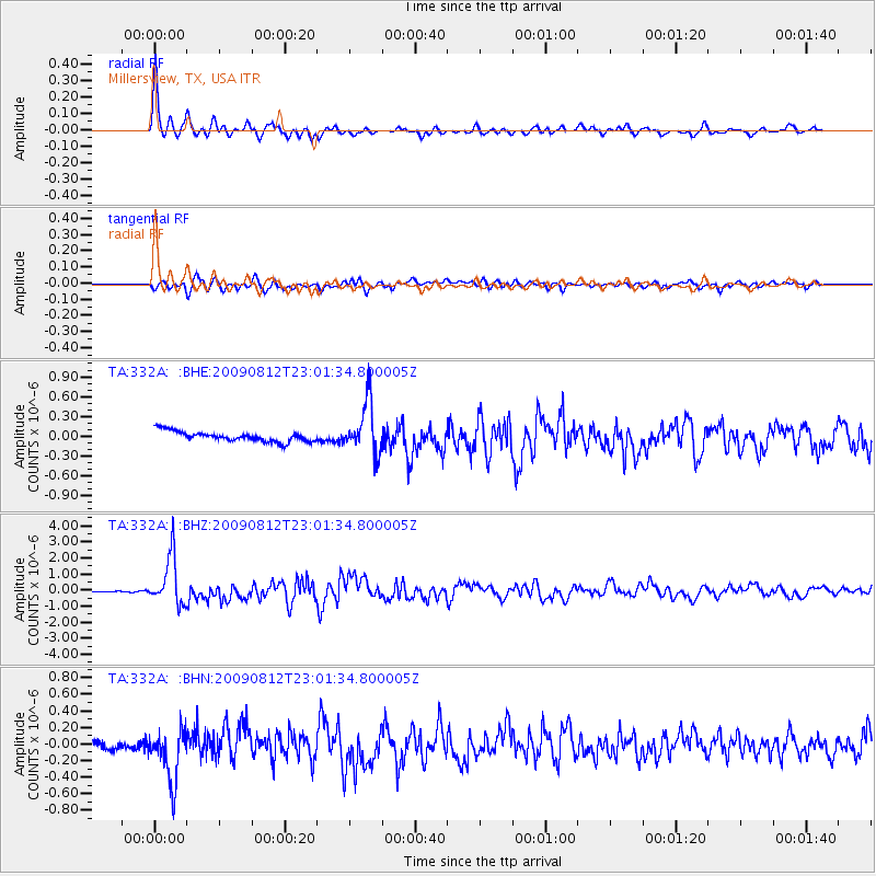
| Radial Match: |
91.88505 % |
| Radial Bump: |
320 |
| Transverse Match: |
75.8921 % |
| Transverse Bump: |
400 |
| SOD ConfigId: |
2622 |
| Insert Time: |
2010-03-05 23:46:37.755 +0000 |
| GWidth: |
2.5 |
| Max Bumps: |
400 |
| Tol: |
0.001 |
|
Signal To Noise
| Channel | StoN | STA | LTA |
| TA:332A: :BHZ:20090812T23:01:34.800005Z | 28.39449 | 1.5115897E-6 | 5.323532E-8 |
| TA:332A: :BHN:20090812T23:01:34.800005Z | 5.213253 | 3.278273E-7 | 6.2883444E-8 |
| TA:332A: :BHE:20090812T23:01:34.800005Z | 5.0194554 | 3.8451677E-7 | 7.6605275E-8 |
| Arrivals |
| Ps | 2.5 SECOND |
| PpPs | 9.2 SECOND |
| PsPs/PpSs | 12 SECOND |


