You are here: Home > Network List > C - Chilean National Seismic Network Stations List
> Station GO02 Mina Guanaco, Chile > Earthquake Result Viewer
GO02 Mina Guanaco, Chile - Earthquake Result Viewer
| Earthquake location: |
South Sandwich Islands Region |
| Earthquake latitude/longitude: |
-56.3/-25.5 |
| Earthquake time(UTC): |
2017/05/10 (130) 23:23:39 GMT |
| Earthquake Depth: |
41 km |
| Earthquake Magnitude: |
6.8 Mi |
| Earthquake Catalog/Contributor: |
NEIC PDE/pt |
|
| Network: |
C Chilean National Seismic Network |
| Station: |
GO02 Mina Guanaco, Chile |
| Lat/Lon: |
25.16 S/69.59 W |
| Elevation: |
2556 m |
|
| Distance: |
44.4 deg |
| Az: |
295.803 deg |
| Baz: |
146.366 deg |
| Ray Param: |
0.07182299 |
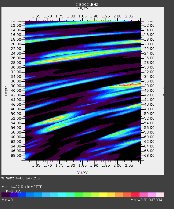
| Estimated Moho Depth: |
37.0 km |
| Estimated Crust Vp/Vs: |
2.06 |
| Assumed Crust Vp: |
6.475 km/s |
| Estimated Crust Vs: |
3.151 km/s |
| Estimated Crust Poisson's Ratio: |
0.34 |
|
| Radial Match: |
86.647255 % |
| Radial Bump: |
400 |
| Transverse Match: |
75.313515 % |
| Transverse Bump: |
400 |
| SOD ConfigId: |
11737051 |
| Insert Time: |
2019-04-27 08:24:55.788 +0000 |
| GWidth: |
2.5 |
| Max Bumps: |
400 |
| Tol: |
0.001 |
|

Signal To Noise
| Channel | StoN | STA | LTA |
| C:GO02: :BHZ:20170510T23:31:15.674988Z | 24.981712 | 6.539826E-6 | 2.6178452E-7 |
| C:GO02: :BHN:20170510T23:31:15.674988Z | 14.42605 | 3.2040343E-6 | 2.221006E-7 |
| C:GO02: :BHE:20170510T23:31:15.674988Z | 3.4983327 | 9.693138E-7 | 2.7707878E-7 |
| Arrivals |
| Ps | 6.4 SECOND |
| PpPs | 16 SECOND |
| PsPs/PpSs | 23 SECOND |


