You are here: Home > Network List > C1 - Red Sismologica Nacional Stations List
> Station CO01 Juntas del Toro > Earthquake Result Viewer
CO01 Juntas del Toro - Earthquake Result Viewer
| Earthquake location: |
South Sandwich Islands Region |
| Earthquake latitude/longitude: |
-56.3/-25.5 |
| Earthquake time(UTC): |
2017/05/10 (130) 23:23:39 GMT |
| Earthquake Depth: |
41 km |
| Earthquake Magnitude: |
6.8 Mi |
| Earthquake Catalog/Contributor: |
NEIC PDE/pt |
|
| Network: |
C1 Red Sismologica Nacional |
| Station: |
CO01 Juntas del Toro |
| Lat/Lon: |
29.98 S/70.09 W |
| Elevation: |
2157 m |
|
| Distance: |
40.8 deg |
| Az: |
291.178 deg |
| Baz: |
143.191 deg |
| Ray Param: |
0.074106075 |
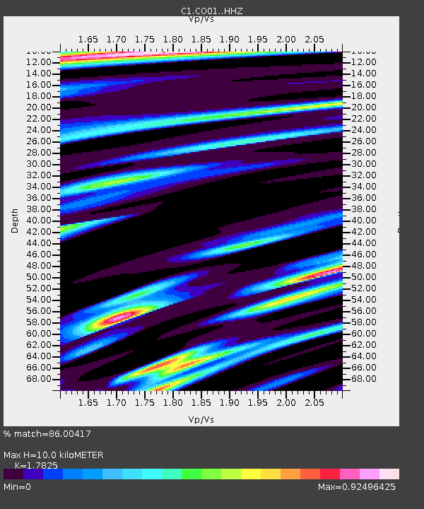
| Estimated Moho Depth: |
10.0 km |
| Estimated Crust Vp/Vs: |
1.78 |
| Assumed Crust Vp: |
6.481 km/s |
| Estimated Crust Vs: |
3.636 km/s |
| Estimated Crust Poisson's Ratio: |
0.27 |
|
| Radial Match: |
86.00417 % |
| Radial Bump: |
400 |
| Transverse Match: |
69.34298 % |
| Transverse Bump: |
400 |
| SOD ConfigId: |
11737051 |
| Insert Time: |
2019-04-27 08:25:09.820 +0000 |
| GWidth: |
2.5 |
| Max Bumps: |
400 |
| Tol: |
0.001 |
|

Signal To Noise
| Channel | StoN | STA | LTA |
| C1:CO01: :HHZ:20170510T23:30:45.820007Z | 8.495977 | 2.7347514E-6 | 3.2188777E-7 |
| C1:CO01: :HHN:20170510T23:30:45.820007Z | 5.670053 | 1.0311853E-6 | 1.818652E-7 |
| C1:CO01: :HHE:20170510T23:30:45.820007Z | 3.3399355 | 9.252567E-7 | 2.770283E-7 |
| Arrivals |
| Ps | 1.3 SECOND |
| PpPs | 4.0 SECOND |
| PsPs/PpSs | 5.3 SECOND |


