You are here: Home > Network List > TA - USArray Transportable Network (new EarthScope stations) Stations List
> Station 332A Millersview, TX, USA > Earthquake Result Viewer
332A Millersview, TX, USA - Earthquake Result Viewer
| Earthquake location: |
East Of Severnaya Zemlya |
| Earthquake latitude/longitude: |
81.6/119.5 |
| Earthquake time(UTC): |
2009/10/07 (280) 20:52:13 GMT |
| Earthquake Depth: |
8.0 km |
| Earthquake Magnitude: |
5.7 MB, 5.1 MS, 5.8 MW, 5.8 MW |
| Earthquake Catalog/Contributor: |
WHDF/NEIC |
|
| Network: |
TA USArray Transportable Network (new EarthScope stations) |
| Station: |
332A Millersview, TX, USA |
| Lat/Lon: |
31.38 N/99.74 W |
| Elevation: |
513 m |
|
| Distance: |
65.5 deg |
| Az: |
36.515 deg |
| Baz: |
354.108 deg |
| Ray Param: |
0.058242317 |
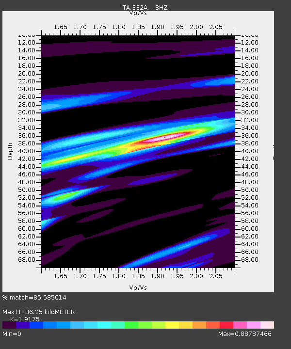
| Estimated Moho Depth: |
36.25 km |
| Estimated Crust Vp/Vs: |
1.92 |
| Assumed Crust Vp: |
6.498 km/s |
| Estimated Crust Vs: |
3.389 km/s |
| Estimated Crust Poisson's Ratio: |
0.31 |
|
| Radial Match: |
85.585014 % |
| Radial Bump: |
400 |
| Transverse Match: |
53.644897 % |
| Transverse Bump: |
400 |
| SOD ConfigId: |
2622 |
| Insert Time: |
2010-03-05 23:46:48.339 +0000 |
| GWidth: |
2.5 |
| Max Bumps: |
400 |
| Tol: |
0.001 |
|
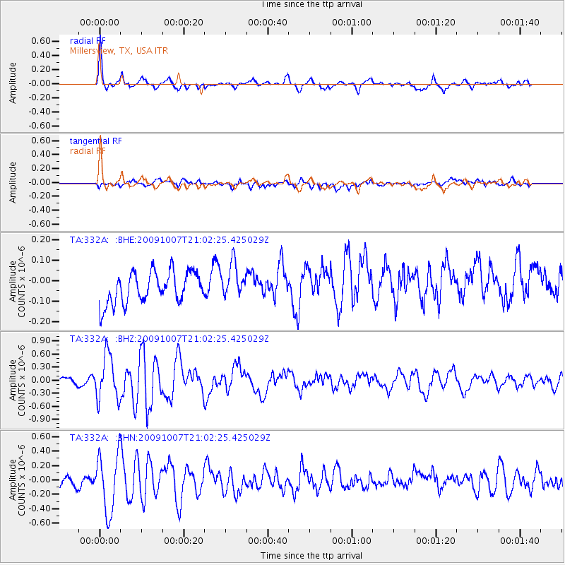
Signal To Noise
| Channel | StoN | STA | LTA |
| TA:332A: :BHZ:20091007T21:02:25.425029Z | 6.244618 | 5.288403E-7 | 8.468738E-8 |
| TA:332A: :BHN:20091007T21:02:25.425029Z | 6.962343 | 4.1199405E-7 | 5.9174624E-8 |
| TA:332A: :BHE:20091007T21:02:25.425029Z | 1.126778 | 8.50755E-8 | 7.550334E-8 |
| Arrivals |
| Ps | 5.3 SECOND |
| PpPs | 16 SECOND |
| PsPs/PpSs | 21 SECOND |


