You are here: Home > Network List > EC - Ecuador Seismic Network Stations List
> Station TULM RENSIG > Earthquake Result Viewer
TULM RENSIG - Earthquake Result Viewer
| Earthquake location: |
South Sandwich Islands Region |
| Earthquake latitude/longitude: |
-56.3/-25.5 |
| Earthquake time(UTC): |
2017/05/10 (130) 23:23:39 GMT |
| Earthquake Depth: |
41 km |
| Earthquake Magnitude: |
6.8 Mi |
| Earthquake Catalog/Contributor: |
NEIC PDE/pt |
|
| Network: |
EC Ecuador Seismic Network |
| Station: |
TULM RENSIG |
| Lat/Lon: |
0.72 N/77.79 W |
| Elevation: |
3677 m |
|
| Distance: |
70.7 deg |
| Az: |
303.068 deg |
| Baz: |
152.144 deg |
| Ray Param: |
0.054749873 |
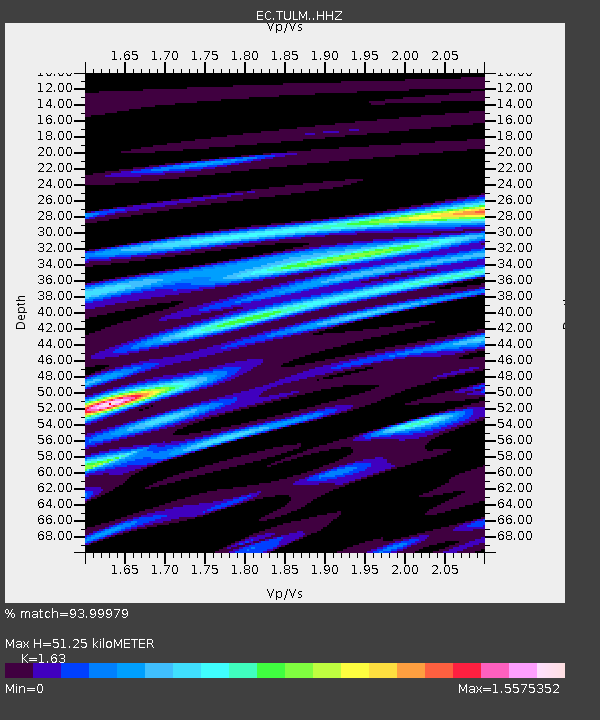
| Estimated Moho Depth: |
51.25 km |
| Estimated Crust Vp/Vs: |
1.63 |
| Assumed Crust Vp: |
6.306 km/s |
| Estimated Crust Vs: |
3.869 km/s |
| Estimated Crust Poisson's Ratio: |
0.20 |
|
| Radial Match: |
93.99979 % |
| Radial Bump: |
400 |
| Transverse Match: |
93.91424 % |
| Transverse Bump: |
400 |
| SOD ConfigId: |
11737051 |
| Insert Time: |
2019-04-27 08:25:45.698 +0000 |
| GWidth: |
2.5 |
| Max Bumps: |
400 |
| Tol: |
0.001 |
|

Signal To Noise
| Channel | StoN | STA | LTA |
| EC:TULM: :HHZ:20170510T23:34:20.40802Z | 15.438906 | 7.567934E-7 | 4.9018592E-8 |
| EC:TULM: :HHN:20170510T23:34:20.40802Z | 3.18872 | 3.3670895E-7 | 1.0559377E-7 |
| EC:TULM: :HHE:20170510T23:34:20.40802Z | 2.409368 | 2.6759278E-7 | 1.1106348E-7 |
| Arrivals |
| Ps | 5.3 SECOND |
| PpPs | 21 SECOND |
| PsPs/PpSs | 26 SECOND |


