You are here: Home > Network List > TA - USArray Transportable Network (new EarthScope stations) Stations List
> Station 332A Millersview, TX, USA > Earthquake Result Viewer
332A Millersview, TX, USA - Earthquake Result Viewer
| Earthquake location: |
Baffin Bay |
| Earthquake latitude/longitude: |
75.4/-72.5 |
| Earthquake time(UTC): |
2009/07/07 (188) 19:11:46 GMT |
| Earthquake Depth: |
19 km |
| Earthquake Magnitude: |
5.9 MB, 5.7 MS, 6.1 MW, 6.0 MW |
| Earthquake Catalog/Contributor: |
WHDF/NEIC |
|
| Network: |
TA USArray Transportable Network (new EarthScope stations) |
| Station: |
332A Millersview, TX, USA |
| Lat/Lon: |
31.38 N/99.74 W |
| Elevation: |
513 m |
|
| Distance: |
46.0 deg |
| Az: |
213.028 deg |
| Baz: |
9.334 deg |
| Ray Param: |
0.07088885 |
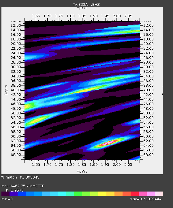
| Estimated Moho Depth: |
62.75 km |
| Estimated Crust Vp/Vs: |
1.96 |
| Assumed Crust Vp: |
6.498 km/s |
| Estimated Crust Vs: |
3.319 km/s |
| Estimated Crust Poisson's Ratio: |
0.32 |
|
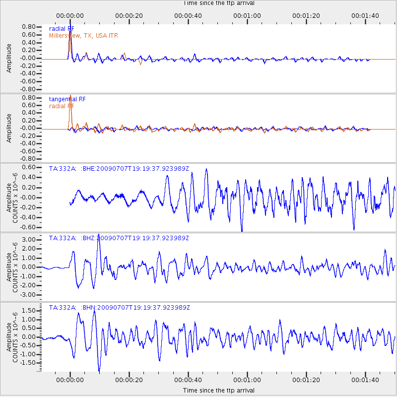
| Radial Match: |
91.395645 % |
| Radial Bump: |
243 |
| Transverse Match: |
77.14181 % |
| Transverse Bump: |
400 |
| SOD ConfigId: |
2648 |
| Insert Time: |
2010-03-05 23:47:09.741 +0000 |
| GWidth: |
2.5 |
| Max Bumps: |
400 |
| Tol: |
0.001 |
|
Signal To Noise
| Channel | StoN | STA | LTA |
| TA:332A: :BHZ:20090707T19:19:37.923989Z | 16.287102 | 1.3163027E-6 | 8.081872E-8 |
| TA:332A: :BHN:20090707T19:19:37.923989Z | 13.871064 | 8.3285886E-7 | 6.004289E-8 |
| TA:332A: :BHE:20090707T19:19:37.923989Z | 2.630846 | 1.9796934E-7 | 7.524931E-8 |
| Arrivals |
| Ps | 9.8 SECOND |
| PpPs | 27 SECOND |
| PsPs/PpSs | 37 SECOND |


