You are here: Home > Network List > TA - USArray Transportable Network (new EarthScope stations) Stations List
> Station 332A Millersview, TX, USA > Earthquake Result Viewer
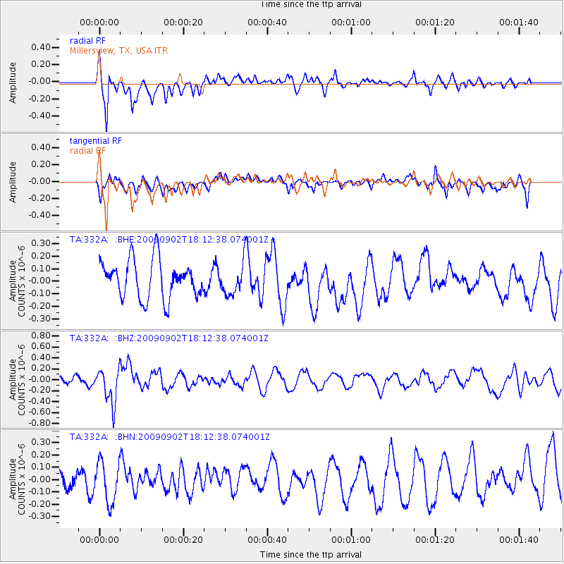
332A Millersview, TX, USA - Earthquake Result Viewer
*The percent match for this event was below the threshold and hence no stack was calculated.
| Earthquake location: |
Kermadec Islands, New Zealand |
| Earthquake latitude/longitude: |
-29.4/-179.0 |
| Earthquake time(UTC): |
2009/09/02 (245) 18:00:11 GMT |
| Earthquake Depth: |
275 km |
| Earthquake Magnitude: |
5.8 MB, 6.2 MW, 6.1 MW |
| Earthquake Catalog/Contributor: |
WHDF/NEIC |
|
| Network: |
TA USArray Transportable Network (new EarthScope stations) |
| Station: |
332A Millersview, TX, USA |
| Lat/Lon: |
31.38 N/99.74 W |
| Elevation: |
513 m |
|
| Distance: |
96.5 deg |
| Az: |
57.733 deg |
| Baz: |
239.667 deg |
| Ray Param: |
$rayparam |
*The percent match for this event was below the threshold and hence was not used in the summary stack. |
|
| Radial Match: |
69.84296 % |
| Radial Bump: |
400 |
| Transverse Match: |
50.718353 % |
| Transverse Bump: |
400 |
| SOD ConfigId: |
2622 |
| Insert Time: |
2010-03-05 23:47:31.588 +0000 |
| GWidth: |
2.5 |
| Max Bumps: |
400 |
| Tol: |
0.001 |
|
Signal To Noise
| Channel | StoN | STA | LTA |
| TA:332A: :BHZ:20090902T18:12:38.074001Z | 2.7559602 | 3.3179174E-7 | 1.2039061E-7 |
| TA:332A: :BHN:20090902T18:12:38.074001Z | 1.7196586 | 1.700223E-7 | 9.8869805E-8 |
| TA:332A: :BHE:20090902T18:12:38.074001Z | 0.8620451 | 1.3062922E-7 | 1.515341E-7 |
| Arrivals |
| Ps | |
| PpPs | |
| PsPs/PpSs | |


