You are here: Home > Network List > TA - USArray Transportable Network (new EarthScope stations) Stations List
> Station 332A Millersview, TX, USA > Earthquake Result Viewer
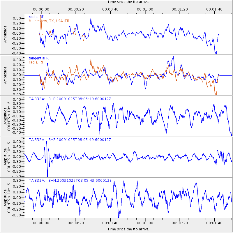
332A Millersview, TX, USA - Earthquake Result Viewer
*The percent match for this event was below the threshold and hence no stack was calculated.
| Earthquake location: |
South Of Fiji Islands |
| Earthquake latitude/longitude: |
-23.1/-179.2 |
| Earthquake time(UTC): |
2009/10/25 (298) 07:53:52 GMT |
| Earthquake Depth: |
418 km |
| Earthquake Magnitude: |
5.6 MB, 6.0 MW, 5.9 MW |
| Earthquake Catalog/Contributor: |
WHDF/NEIC |
|
| Network: |
TA USArray Transportable Network (new EarthScope stations) |
| Station: |
332A Millersview, TX, USA |
| Lat/Lon: |
31.38 N/99.74 W |
| Elevation: |
513 m |
|
| Distance: |
93.3 deg |
| Az: |
57.379 deg |
| Baz: |
245.071 deg |
| Ray Param: |
$rayparam |
*The percent match for this event was below the threshold and hence was not used in the summary stack. |
|
| Radial Match: |
56.640224 % |
| Radial Bump: |
400 |
| Transverse Match: |
54.980362 % |
| Transverse Bump: |
400 |
| SOD ConfigId: |
2622 |
| Insert Time: |
2010-03-05 23:47:42.544 +0000 |
| GWidth: |
2.5 |
| Max Bumps: |
400 |
| Tol: |
0.001 |
|
Signal To Noise
| Channel | StoN | STA | LTA |
| TA:332A: :BHZ:20091025T08:05:49.600012Z | 3.9888816 | 4.2353025E-7 | 1.0617769E-7 |
| TA:332A: :BHN:20091025T08:05:49.600012Z | 0.98556304 | 1.05824085E-7 | 1.0737425E-7 |
| TA:332A: :BHE:20091025T08:05:49.600012Z | 0.93423647 | 1.3294881E-7 | 1.4230744E-7 |
| Arrivals |
| Ps | |
| PpPs | |
| PsPs/PpSs | |


