You are here: Home > Network List > TA - USArray Transportable Network (new EarthScope stations) Stations List
> Station 332A Millersview, TX, USA > Earthquake Result Viewer
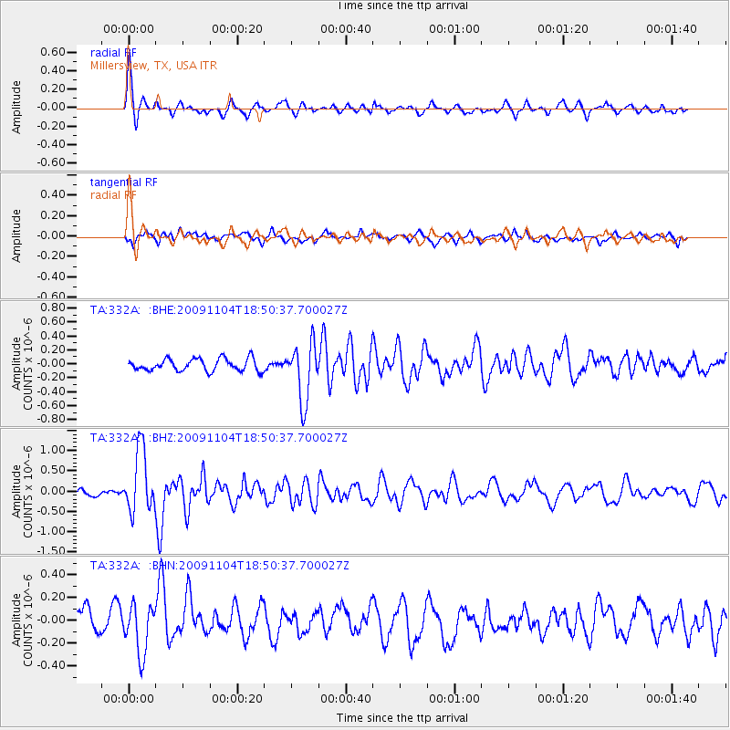
332A Millersview, TX, USA - Earthquake Result Viewer
*The percent match for this event was below the threshold and hence no stack was calculated.
| Earthquake location: |
Azores Islands Region |
| Earthquake latitude/longitude: |
36.2/-33.9 |
| Earthquake time(UTC): |
2009/11/04 (308) 18:41:44 GMT |
| Earthquake Depth: |
10 km |
| Earthquake Magnitude: |
5.7 MB, 5.6 MS, 5.9 MW, 5.8 MW |
| Earthquake Catalog/Contributor: |
WHDF/NEIC |
|
| Network: |
TA USArray Transportable Network (new EarthScope stations) |
| Station: |
332A Millersview, TX, USA |
| Lat/Lon: |
31.38 N/99.74 W |
| Elevation: |
513 m |
|
| Distance: |
54.0 deg |
| Az: |
285.333 deg |
| Baz: |
65.867 deg |
| Ray Param: |
$rayparam |
*The percent match for this event was below the threshold and hence was not used in the summary stack. |
|
| Radial Match: |
78.59245 % |
| Radial Bump: |
364 |
| Transverse Match: |
60.741787 % |
| Transverse Bump: |
400 |
| SOD ConfigId: |
2622 |
| Insert Time: |
2010-03-05 23:47:49.648 +0000 |
| GWidth: |
2.5 |
| Max Bumps: |
400 |
| Tol: |
0.001 |
|
Signal To Noise
| Channel | StoN | STA | LTA |
| TA:332A: :BHZ:20091104T18:50:37.700027Z | 6.3177814 | 7.811959E-7 | 1.2365037E-7 |
| TA:332A: :BHN:20091104T18:50:37.700027Z | 1.7241349 | 2.0747486E-7 | 1.2033563E-7 |
| TA:332A: :BHE:20091104T18:50:37.700027Z | 4.736762 | 4.1673198E-7 | 8.7978236E-8 |
| Arrivals |
| Ps | |
| PpPs | |
| PsPs/PpSs | |


