You are here: Home > Network List > TA - USArray Transportable Network (new EarthScope stations) Stations List
> Station 332A Millersview, TX, USA > Earthquake Result Viewer
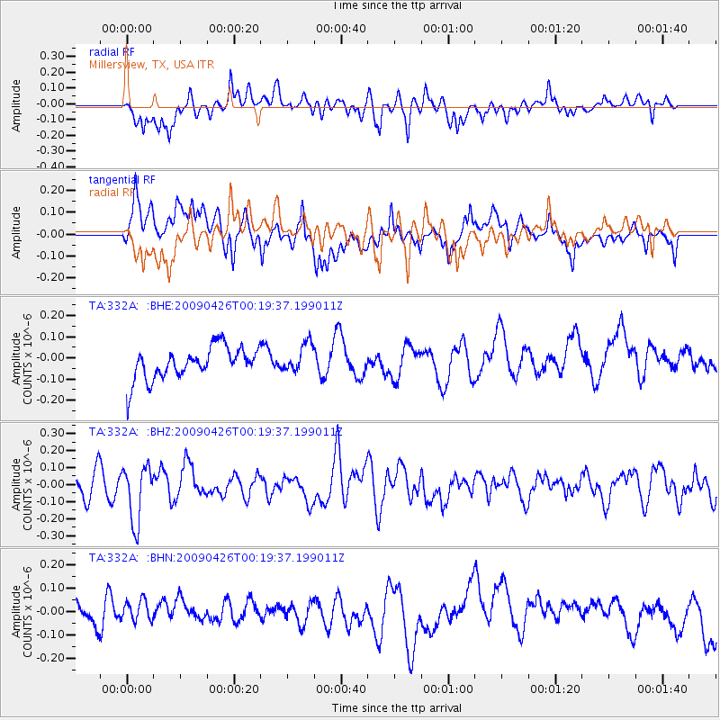
332A Millersview, TX, USA - Earthquake Result Viewer
*The percent match for this event was below the threshold and hence no stack was calculated.
| Earthquake location: |
Kermadec Islands, New Zealand |
| Earthquake latitude/longitude: |
-30.3/-178.6 |
| Earthquake time(UTC): |
2009/04/26 (116) 00:06:53 GMT |
| Earthquake Depth: |
132 km |
| Earthquake Magnitude: |
5.5 MB, 6.1 MW, 6.1 MW |
| Earthquake Catalog/Contributor: |
WHDF/NEIC |
|
| Network: |
TA USArray Transportable Network (new EarthScope stations) |
| Station: |
332A Millersview, TX, USA |
| Lat/Lon: |
31.38 N/99.74 W |
| Elevation: |
513 m |
|
| Distance: |
96.7 deg |
| Az: |
57.659 deg |
| Baz: |
238.691 deg |
| Ray Param: |
$rayparam |
*The percent match for this event was below the threshold and hence was not used in the summary stack. |
|
| Radial Match: |
50.179207 % |
| Radial Bump: |
400 |
| Transverse Match: |
48.849533 % |
| Transverse Bump: |
400 |
| SOD ConfigId: |
2658 |
| Insert Time: |
2010-03-05 23:48:01.571 +0000 |
| GWidth: |
2.5 |
| Max Bumps: |
400 |
| Tol: |
0.001 |
|
Signal To Noise
| Channel | StoN | STA | LTA |
| TA:332A: :BHZ:20090426T00:19:37.199011Z | 2.3465886 | 1.6655036E-7 | 7.097553E-8 |
| TA:332A: :BHN:20090426T00:19:37.199011Z | 1.2203798 | 5.0118153E-8 | 4.1067665E-8 |
| TA:332A: :BHE:20090426T00:19:37.199011Z | 0.9131973 | 6.909086E-8 | 7.56582E-8 |
| Arrivals |
| Ps | |
| PpPs | |
| PsPs/PpSs | |


