You are here: Home > Network List > TA - USArray Transportable Network (new EarthScope stations) Stations List
> Station 332A Millersview, TX, USA > Earthquake Result Viewer
332A Millersview, TX, USA - Earthquake Result Viewer
*The percent match for this event was below the threshold and hence no stack was calculated.
| Earthquake location: |
Tonga Islands |
| Earthquake latitude/longitude: |
-16.8/-173.5 |
| Earthquake time(UTC): |
2009/05/17 (137) 06:23:03 GMT |
| Earthquake Depth: |
67 km |
| Earthquake Magnitude: |
5.5 MB, 5.6 MW, 5.6 MW |
| Earthquake Catalog/Contributor: |
WHDF/NEIC |
|
| Network: |
TA USArray Transportable Network (new EarthScope stations) |
| Station: |
332A Millersview, TX, USA |
| Lat/Lon: |
31.38 N/99.74 W |
| Elevation: |
513 m |
|
| Distance: |
85.4 deg |
| Az: |
55.46 deg |
| Baz: |
247.284 deg |
| Ray Param: |
$rayparam |
*The percent match for this event was below the threshold and hence was not used in the summary stack. |
|
| Radial Match: |
70.1344 % |
| Radial Bump: |
400 |
| Transverse Match: |
73.10053 % |
| Transverse Bump: |
400 |
| SOD ConfigId: |
2760 |
| Insert Time: |
2010-03-05 23:48:06.213 +0000 |
| GWidth: |
2.5 |
| Max Bumps: |
400 |
| Tol: |
0.001 |
|
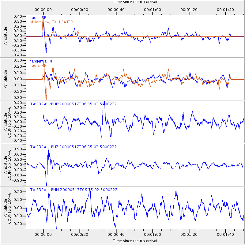
Signal To Noise
| Channel | StoN | STA | LTA |
| TA:332A: :BHZ:20090517T06:35:02.500022Z | 6.8545947 | 4.883534E-7 | 7.124468E-8 |
| TA:332A: :BHN:20090517T06:35:02.500022Z | 1.2618943 | 8.844214E-8 | 7.0086806E-8 |
| TA:332A: :BHE:20090517T06:35:02.500022Z | 2.8467567 | 2.0575818E-7 | 7.227811E-8 |
| Arrivals |
| Ps | |
| PpPs | |
| PsPs/PpSs | |


