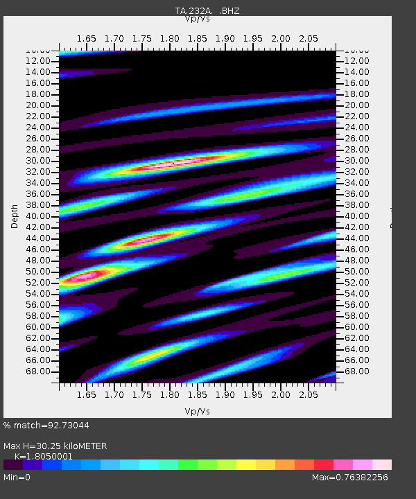
232A Coleman, TX, USA - Earthquake Result Viewer

Earthquake location: Fox Islands, Aleutian Islands
Earthquake latitude/longitude: 52.8/-167.0
Earthquake time(UTC): 2009/10/13 (286) 05:37:23 GMT
Earthquake Depth: 24 km
Earthquake Magnitude: 6.0 MB, 6.1 MS, 6.5 MW, 6.5 MW
Earthquake Catalog/Contributor: WHDF/NEIC
Network: TA USArray Transportable Network (new EarthScope stations)
Station: 232A Coleman, TX, USA
Lat/Lon: 31.89 N/99.65 W
Elevation: 621 m
Distance: 51.9 deg
Az: 85.673 deg
Baz: 314.563 deg
Ray Param: 0.06704958
Estimated Moho Depth: 30.25 km
Estimated Crust Vp/Vs: 1.81
Assumed Crust Vp: 6.498 km/s
Estimated Crust Vs: 3.6 km/s
Estimated Crust Poisson's Ratio: 0.28
Radial Match: 92.73044 %
Radial Bump: 385
Transverse Match: 49.436085 %
Transverse Bump: 400
SOD ConfigId: 2622
Insert Time: 2010-03-05 23:48:21.472 +0000
GWidth: 2.5
Max Bumps: 400
Tol: 0.001

Signal To Noise

ChannelStoNSTALTA
TA:232A: :BHZ:20091013T05:45:59.624021Z2.54895973.3863603E-71.3285263E-7
TA:232A: :BHN:20091013T05:45:59.624021Z0.59217681.1511969E-71.9440088E-7
TA:232A: :BHE:20091013T05:45:59.624021Z1.67854492.1504847E-71.2811601E-7
Arrivals
Ps4.0 SECOND
PpPs12 SECOND
PsPs/PpSs16 SECOND