You are here: Home > Network List > TA - USArray Transportable Network (new EarthScope stations) Stations List
> Station F21K Alatna River, AK, USA > Earthquake Result Viewer
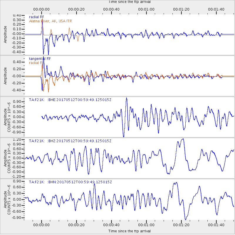
F21K Alatna River, AK, USA - Earthquake Result Viewer
*The percent match for this event was below the threshold and hence no stack was calculated.
| Earthquake location: |
Kermadec Islands Region |
| Earthquake latitude/longitude: |
-27.5/-176.9 |
| Earthquake time(UTC): |
2017/05/12 (132) 00:46:52 GMT |
| Earthquake Depth: |
10 km |
| Earthquake Magnitude: |
5.8 mb |
| Earthquake Catalog/Contributor: |
NEIC PDE/us |
|
| Network: |
TA USArray Transportable Network (new EarthScope stations) |
| Station: |
F21K Alatna River, AK, USA |
| Lat/Lon: |
67.22 N/153.48 W |
| Elevation: |
597 m |
|
| Distance: |
96.0 deg |
| Az: |
8.939 deg |
| Baz: |
200.767 deg |
| Ray Param: |
$rayparam |
*The percent match for this event was below the threshold and hence was not used in the summary stack. |
|
| Radial Match: |
76.33304 % |
| Radial Bump: |
400 |
| Transverse Match: |
52.45441 % |
| Transverse Bump: |
400 |
| SOD ConfigId: |
11737051 |
| Insert Time: |
2019-04-27 08:45:16.752 +0000 |
| GWidth: |
2.5 |
| Max Bumps: |
400 |
| Tol: |
0.001 |
|
Signal To Noise
| Channel | StoN | STA | LTA |
| TA:F21K: :BHZ:20170512T00:59:49.125015Z | 1.7595509 | 2.0164946E-7 | 1.1460279E-7 |
| TA:F21K: :BHN:20170512T00:59:49.125015Z | 1.8176273 | 1.6313365E-7 | 8.9750884E-8 |
| TA:F21K: :BHE:20170512T00:59:49.125015Z | 1.2869521 | 1.1721851E-7 | 9.108226E-8 |
| Arrivals |
| Ps | |
| PpPs | |
| PsPs/PpSs | |


