You are here: Home > Network List > TA - USArray Transportable Network (new EarthScope stations) Stations List
> Station G22K Bettles, AK, USA > Earthquake Result Viewer
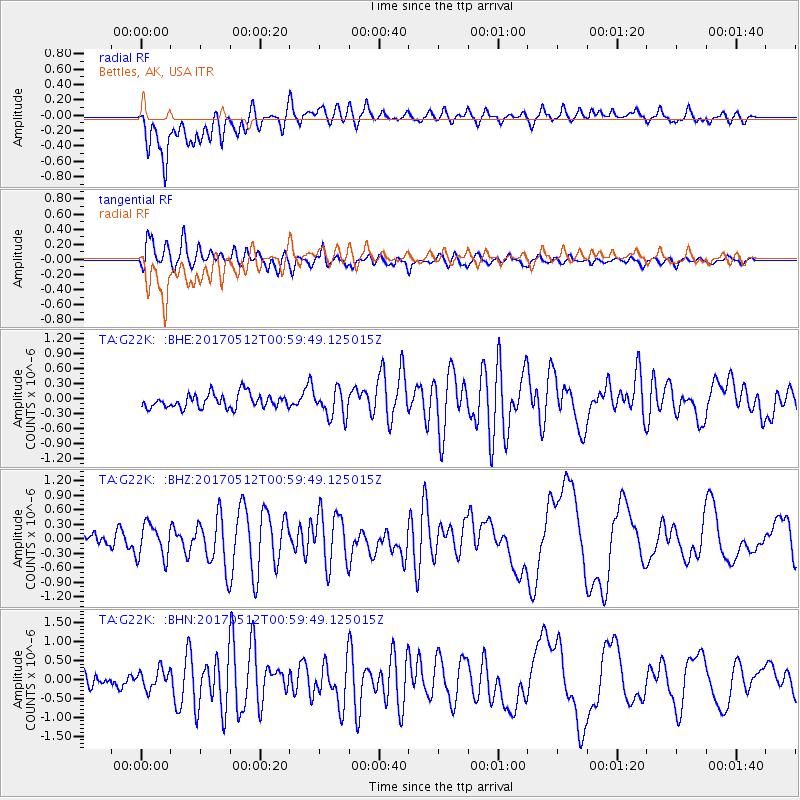
G22K Bettles, AK, USA - Earthquake Result Viewer
*The percent match for this event was below the threshold and hence no stack was calculated.
| Earthquake location: |
Kermadec Islands Region |
| Earthquake latitude/longitude: |
-27.5/-176.9 |
| Earthquake time(UTC): |
2017/05/12 (132) 00:46:52 GMT |
| Earthquake Depth: |
10 km |
| Earthquake Magnitude: |
5.8 mb |
| Earthquake Catalog/Contributor: |
NEIC PDE/us |
|
| Network: |
TA USArray Transportable Network (new EarthScope stations) |
| Station: |
G22K Bettles, AK, USA |
| Lat/Lon: |
66.92 N/151.51 W |
| Elevation: |
205 m |
|
| Distance: |
96.0 deg |
| Az: |
9.775 deg |
| Baz: |
202.496 deg |
| Ray Param: |
$rayparam |
*The percent match for this event was below the threshold and hence was not used in the summary stack. |
|
| Radial Match: |
69.14683 % |
| Radial Bump: |
400 |
| Transverse Match: |
58.795227 % |
| Transverse Bump: |
400 |
| SOD ConfigId: |
11737051 |
| Insert Time: |
2019-04-27 08:45:18.726 +0000 |
| GWidth: |
2.5 |
| Max Bumps: |
400 |
| Tol: |
0.001 |
|
Signal To Noise
| Channel | StoN | STA | LTA |
| TA:G22K: :BHZ:20170512T00:59:49.125015Z | 2.4907677 | 3.5022765E-7 | 1.4061033E-7 |
| TA:G22K: :BHN:20170512T00:59:49.125015Z | 1.6469822 | 2.5592135E-7 | 1.5538805E-7 |
| TA:G22K: :BHE:20170512T00:59:49.125015Z | 2.0488608 | 2.86169E-7 | 1.3967225E-7 |
| Arrivals |
| Ps | |
| PpPs | |
| PsPs/PpSs | |


