You are here: Home > Network List > UW - Pacific Northwest Regional Seismic Network Stations List
> Station HOOD Mt Hood Meadows, OR CREST BB SMO > Earthquake Result Viewer
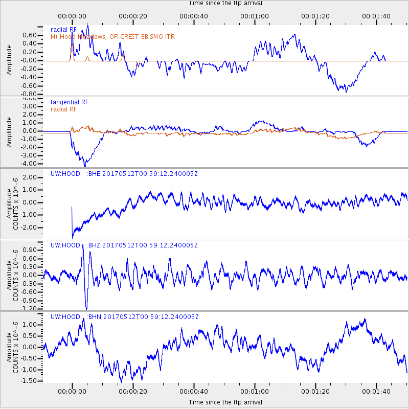
HOOD Mt Hood Meadows, OR CREST BB SMO - Earthquake Result Viewer
*The percent match for this event was below the threshold and hence no stack was calculated.
| Earthquake location: |
Kermadec Islands Region |
| Earthquake latitude/longitude: |
-27.5/-176.9 |
| Earthquake time(UTC): |
2017/05/12 (132) 00:46:52 GMT |
| Earthquake Depth: |
10 km |
| Earthquake Magnitude: |
5.8 mb |
| Earthquake Catalog/Contributor: |
NEIC PDE/us |
|
| Network: |
UW Pacific Northwest Regional Seismic Network |
| Station: |
HOOD Mt Hood Meadows, OR CREST BB SMO |
| Lat/Lon: |
45.32 N/121.65 W |
| Elevation: |
1520 m |
|
| Distance: |
88.1 deg |
| Az: |
35.431 deg |
| Baz: |
226.89 deg |
| Ray Param: |
$rayparam |
*The percent match for this event was below the threshold and hence was not used in the summary stack. |
|
| Radial Match: |
45.229645 % |
| Radial Bump: |
400 |
| Transverse Match: |
53.776463 % |
| Transverse Bump: |
400 |
| SOD ConfigId: |
11737051 |
| Insert Time: |
2019-04-27 08:46:28.415 +0000 |
| GWidth: |
2.5 |
| Max Bumps: |
400 |
| Tol: |
0.001 |
|
Signal To Noise
| Channel | StoN | STA | LTA |
| UW:HOOD: :BHZ:20170512T00:59:12.240005Z | 5.190199 | 5.183338E-7 | 9.986781E-8 |
| UW:HOOD: :BHN:20170512T00:59:12.240005Z | 0.48518905 | 3.1741482E-7 | 6.542085E-7 |
| UW:HOOD: :BHE:20170512T00:59:12.240005Z | 1.511749 | 1.1972843E-6 | 7.9198617E-7 |
| Arrivals |
| Ps | |
| PpPs | |
| PsPs/PpSs | |


