You are here: Home > Network List > TA - USArray Transportable Network (new EarthScope stations) Stations List
> Station 232A Coleman, TX, USA > Earthquake Result Viewer
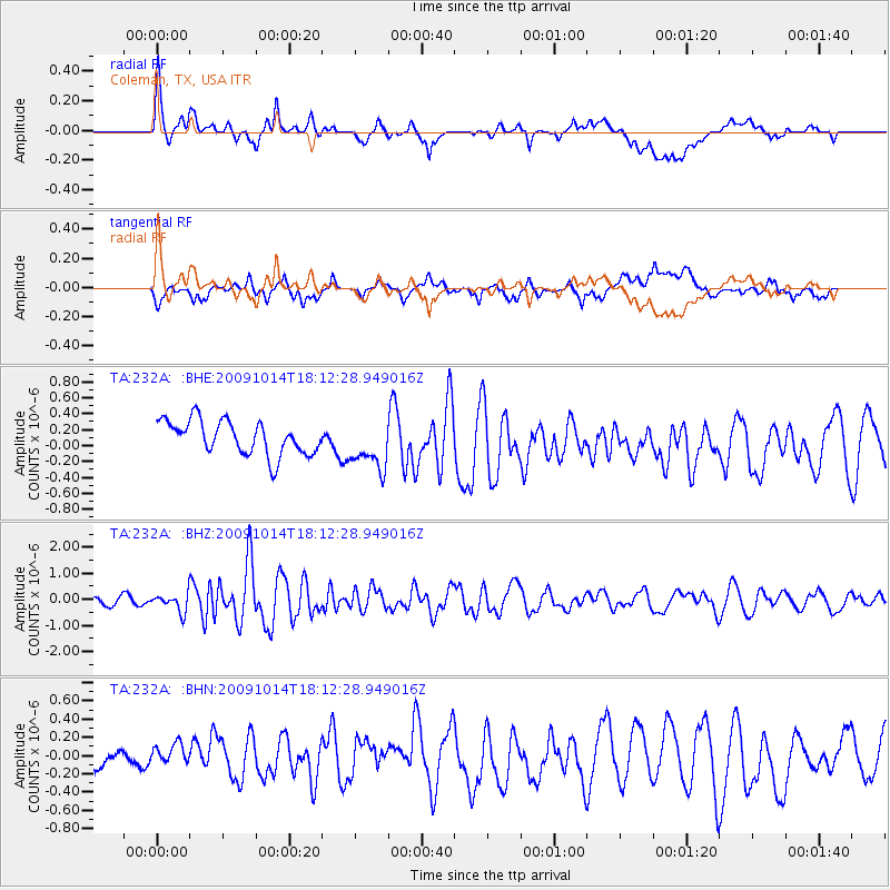
232A Coleman, TX, USA - Earthquake Result Viewer
*The percent match for this event was below the threshold and hence no stack was calculated.
| Earthquake location: |
Samoa Islands Region |
| Earthquake latitude/longitude: |
-14.9/-174.8 |
| Earthquake time(UTC): |
2009/10/14 (287) 18:00:21 GMT |
| Earthquake Depth: |
10 km |
| Earthquake Magnitude: |
5.7 MB, 6.0 MS, 6.3 MW, 6.2 MW |
| Earthquake Catalog/Contributor: |
WHDF/NEIC |
|
| Network: |
TA USArray Transportable Network (new EarthScope stations) |
| Station: |
232A Coleman, TX, USA |
| Lat/Lon: |
31.89 N/99.65 W |
| Elevation: |
621 m |
|
| Distance: |
85.6 deg |
| Az: |
55.562 deg |
| Baz: |
249.602 deg |
| Ray Param: |
$rayparam |
*The percent match for this event was below the threshold and hence was not used in the summary stack. |
|
| Radial Match: |
72.52796 % |
| Radial Bump: |
400 |
| Transverse Match: |
47.43891 % |
| Transverse Bump: |
400 |
| SOD ConfigId: |
2622 |
| Insert Time: |
2010-03-05 23:49:05.322 +0000 |
| GWidth: |
2.5 |
| Max Bumps: |
400 |
| Tol: |
0.001 |
|
Signal To Noise
| Channel | StoN | STA | LTA |
| TA:232A: :BHZ:20091014T18:12:28.949016Z | 2.750061 | 3.439611E-7 | 1.2507398E-7 |
| TA:232A: :BHN:20091014T18:12:28.949016Z | 0.33329272 | 9.259002E-8 | 2.778039E-7 |
| TA:232A: :BHE:20091014T18:12:28.949016Z | 1.4419755 | 3.0585005E-7 | 2.1210488E-7 |
| Arrivals |
| Ps | |
| PpPs | |
| PsPs/PpSs | |


