You are here: Home > Network List > AK - Alaska Regional Network Stations List
> Station RIDG Independent Ridge > Earthquake Result Viewer
RIDG Independent Ridge - Earthquake Result Viewer
| Earthquake location: |
Off Coast Of Central America |
| Earthquake latitude/longitude: |
12.9/-90.1 |
| Earthquake time(UTC): |
2017/05/12 (132) 10:41:26 GMT |
| Earthquake Depth: |
10 km |
| Earthquake Magnitude: |
6.2 Mww |
| Earthquake Catalog/Contributor: |
NEIC PDE/us |
|
| Network: |
AK Alaska Regional Network |
| Station: |
RIDG Independent Ridge |
| Lat/Lon: |
63.74 N/144.84 W |
| Elevation: |
888 m |
|
| Distance: |
63.3 deg |
| Az: |
336.001 deg |
| Baz: |
116.938 deg |
| Ray Param: |
0.059650674 |
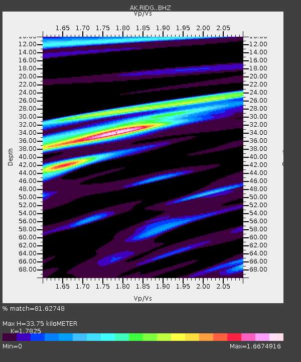
| Estimated Moho Depth: |
33.75 km |
| Estimated Crust Vp/Vs: |
1.78 |
| Assumed Crust Vp: |
6.566 km/s |
| Estimated Crust Vs: |
3.684 km/s |
| Estimated Crust Poisson's Ratio: |
0.27 |
|
| Radial Match: |
81.62748 % |
| Radial Bump: |
400 |
| Transverse Match: |
74.442314 % |
| Transverse Bump: |
400 |
| SOD ConfigId: |
11737051 |
| Insert Time: |
2019-04-27 08:49:35.728 +0000 |
| GWidth: |
2.5 |
| Max Bumps: |
400 |
| Tol: |
0.001 |
|

Signal To Noise
| Channel | StoN | STA | LTA |
| AK:RIDG: :BHZ:20170512T10:51:24.307979Z | 10.00397 | 5.0556827E-7 | 5.0536766E-8 |
| AK:RIDG: :BHN:20170512T10:51:24.307979Z | 1.1797652 | 8.7074596E-8 | 7.380672E-8 |
| AK:RIDG: :BHE:20170512T10:51:24.307979Z | 1.5432715 | 2.0107635E-7 | 1.3029226E-7 |
| Arrivals |
| Ps | 4.2 SECOND |
| PpPs | 14 SECOND |
| PsPs/PpSs | 18 SECOND |


