You are here: Home > Network List > TA - USArray Transportable Network (new EarthScope stations) Stations List
> Station Z32A Haskell, TX, USA > Earthquake Result Viewer
Z32A Haskell, TX, USA - Earthquake Result Viewer
| Earthquake location: |
Norwegian Sea |
| Earthquake latitude/longitude: |
72.2/0.9 |
| Earthquake time(UTC): |
2009/08/20 (232) 06:35:04 GMT |
| Earthquake Depth: |
6.0 km |
| Earthquake Magnitude: |
5.9 MB, 5.7 MS, 6.0 MW, 6.0 MW |
| Earthquake Catalog/Contributor: |
WHDF/NEIC |
|
| Network: |
TA USArray Transportable Network (new EarthScope stations) |
| Station: |
Z32A Haskell, TX, USA |
| Lat/Lon: |
33.31 N/99.48 W |
| Elevation: |
427 m |
|
| Distance: |
61.7 deg |
| Az: |
290.763 deg |
| Baz: |
20.085 deg |
| Ray Param: |
0.060689744 |
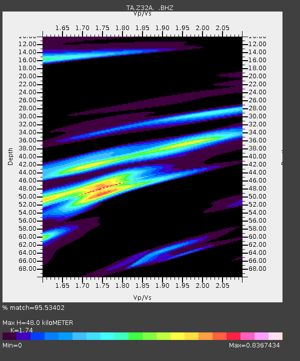
| Estimated Moho Depth: |
48.0 km |
| Estimated Crust Vp/Vs: |
1.74 |
| Assumed Crust Vp: |
6.426 km/s |
| Estimated Crust Vs: |
3.693 km/s |
| Estimated Crust Poisson's Ratio: |
0.25 |
|
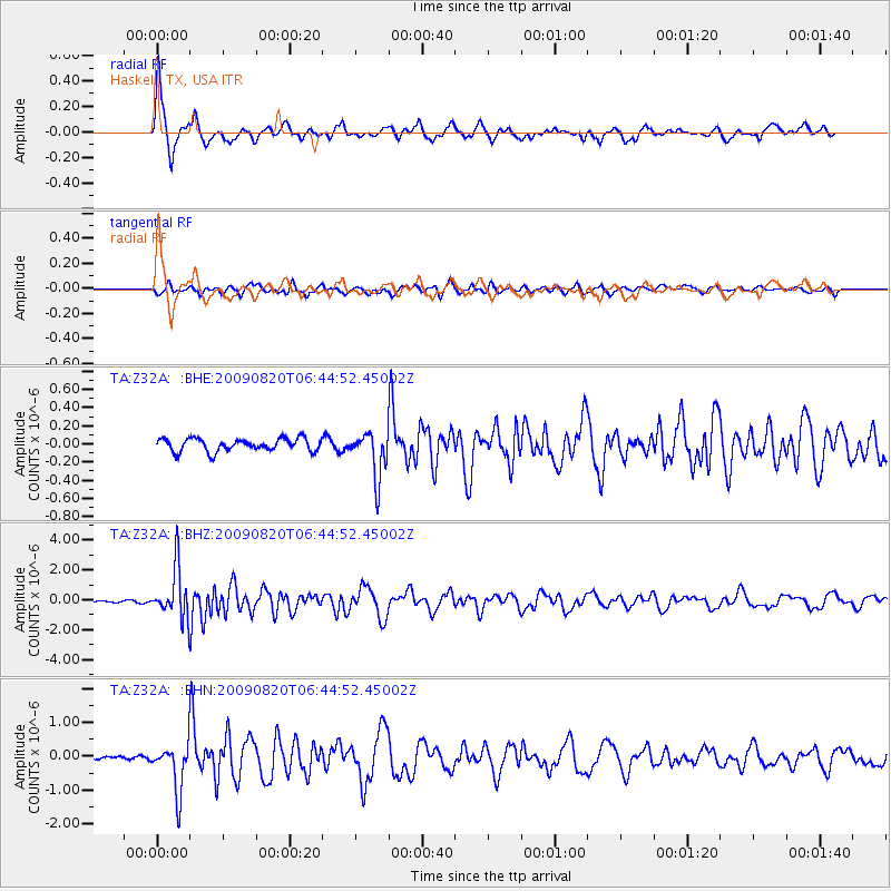
| Radial Match: |
95.53402 % |
| Radial Bump: |
345 |
| Transverse Match: |
76.93604 % |
| Transverse Bump: |
400 |
| SOD ConfigId: |
2622 |
| Insert Time: |
2010-03-05 23:49:45.946 +0000 |
| GWidth: |
2.5 |
| Max Bumps: |
400 |
| Tol: |
0.001 |
|
Signal To Noise
| Channel | StoN | STA | LTA |
| TA:Z32A: :BHZ:20090820T06:44:52.45002Z | 33.42264 | 1.6624043E-6 | 4.9738865E-8 |
| TA:Z32A: :BHN:20090820T06:44:52.45002Z | 13.559484 | 7.0330003E-7 | 5.1867758E-8 |
| TA:Z32A: :BHE:20090820T06:44:52.45002Z | 3.5645752 | 2.5115094E-7 | 7.045747E-8 |
| Arrivals |
| Ps | 5.8 SECOND |
| PpPs | 20 SECOND |
| PsPs/PpSs | 25 SECOND |


