You are here: Home > Network List > TA - USArray Transportable Network (new EarthScope stations) Stations List
> Station Z32A Haskell, TX, USA > Earthquake Result Viewer
Z32A Haskell, TX, USA - Earthquake Result Viewer
| Earthquake location: |
Samoa Islands Region |
| Earthquake latitude/longitude: |
-15.2/-172.6 |
| Earthquake time(UTC): |
2009/08/30 (242) 14:51:32 GMT |
| Earthquake Depth: |
11 km |
| Earthquake Magnitude: |
6.4 MB, 6.3 MS, 6.6 MW, 6.6 MW |
| Earthquake Catalog/Contributor: |
WHDF/NEIC |
|
| Network: |
TA USArray Transportable Network (new EarthScope stations) |
| Station: |
Z32A Haskell, TX, USA |
| Lat/Lon: |
33.31 N/99.48 W |
| Elevation: |
427 m |
|
| Distance: |
84.7 deg |
| Az: |
53.58 deg |
| Baz: |
248.065 deg |
| Ray Param: |
0.04529811 |
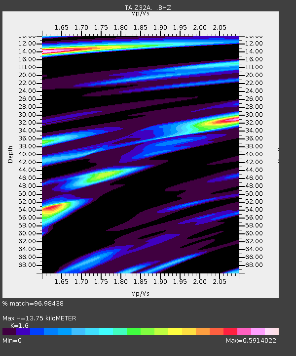
| Estimated Moho Depth: |
13.75 km |
| Estimated Crust Vp/Vs: |
1.60 |
| Assumed Crust Vp: |
6.426 km/s |
| Estimated Crust Vs: |
4.016 km/s |
| Estimated Crust Poisson's Ratio: |
0.18 |
|
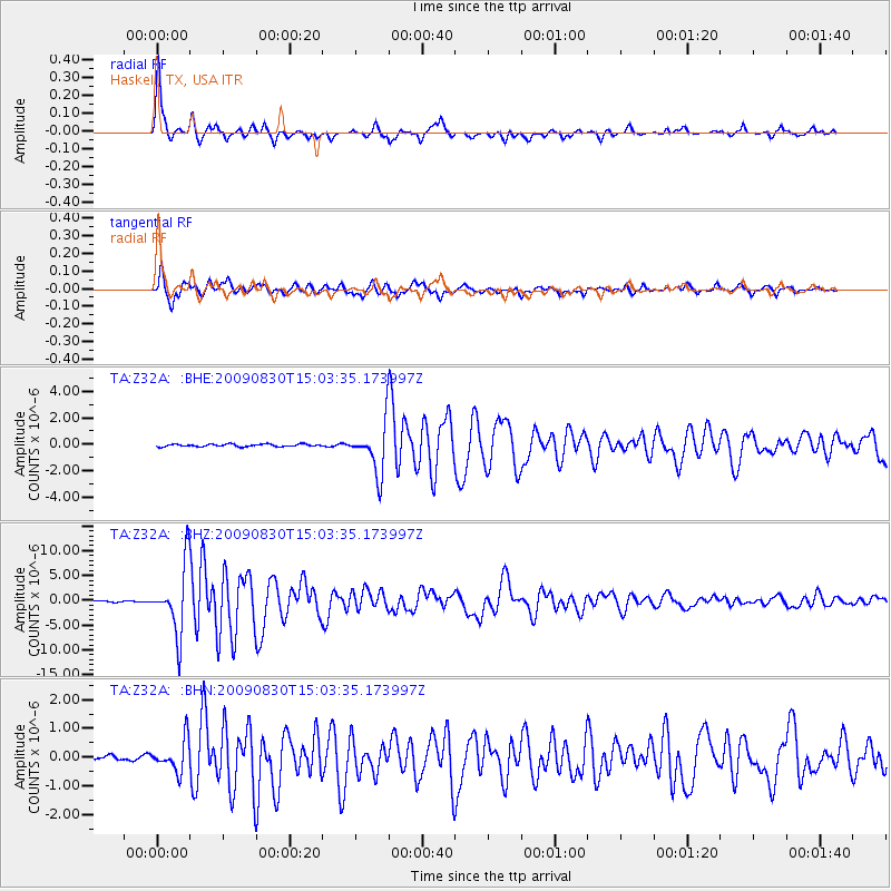
| Radial Match: |
96.98438 % |
| Radial Bump: |
282 |
| Transverse Match: |
94.5763 % |
| Transverse Bump: |
400 |
| SOD ConfigId: |
2622 |
| Insert Time: |
2010-03-05 23:49:47.508 +0000 |
| GWidth: |
2.5 |
| Max Bumps: |
400 |
| Tol: |
0.001 |
|
Signal To Noise
| Channel | StoN | STA | LTA |
| TA:Z32A: :BHZ:20090830T15:03:35.173997Z | 68.275116 | 6.781009E-6 | 9.931889E-8 |
| TA:Z32A: :BHN:20090830T15:03:35.173997Z | 6.0843296 | 5.4309686E-7 | 8.9261576E-8 |
| TA:Z32A: :BHE:20090830T15:03:35.173997Z | 20.257164 | 1.8640892E-6 | 9.202123E-8 |
| Arrivals |
| Ps | 1.3 SECOND |
| PpPs | 5.4 SECOND |
| PsPs/PpSs | 6.7 SECOND |


