You are here: Home > Network List > TA - USArray Transportable Network (new EarthScope stations) Stations List
> Station Z32A Haskell, TX, USA > Earthquake Result Viewer
Z32A Haskell, TX, USA - Earthquake Result Viewer
| Earthquake location: |
Hokkaido, Japan Region |
| Earthquake latitude/longitude: |
41.8/143.4 |
| Earthquake time(UTC): |
2009/06/05 (156) 03:30:33 GMT |
| Earthquake Depth: |
29 km |
| Earthquake Magnitude: |
6.0 MB, 6.3 MS, 6.4 MW, 6.4 MW |
| Earthquake Catalog/Contributor: |
WHDF/NEIC |
|
| Network: |
TA USArray Transportable Network (new EarthScope stations) |
| Station: |
Z32A Haskell, TX, USA |
| Lat/Lon: |
33.31 N/99.48 W |
| Elevation: |
427 m |
|
| Distance: |
85.5 deg |
| Az: |
48.412 deg |
| Baz: |
318.122 deg |
| Ray Param: |
0.044673823 |
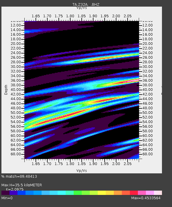
| Estimated Moho Depth: |
35.5 km |
| Estimated Crust Vp/Vs: |
2.10 |
| Assumed Crust Vp: |
6.426 km/s |
| Estimated Crust Vs: |
3.064 km/s |
| Estimated Crust Poisson's Ratio: |
0.35 |
|
| Radial Match: |
89.48413 % |
| Radial Bump: |
317 |
| Transverse Match: |
76.4285 % |
| Transverse Bump: |
398 |
| SOD ConfigId: |
2648 |
| Insert Time: |
2010-03-05 23:49:59.649 +0000 |
| GWidth: |
2.5 |
| Max Bumps: |
400 |
| Tol: |
0.001 |
|
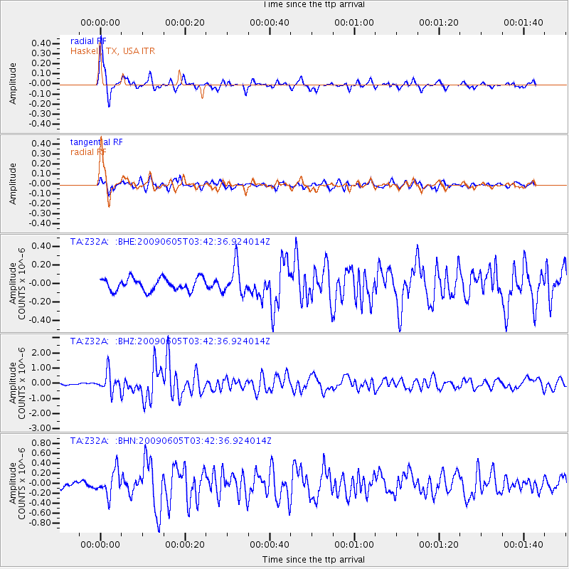
Signal To Noise
| Channel | StoN | STA | LTA |
| TA:Z32A: :BHZ:20090605T03:42:36.924014Z | 10.46875 | 6.62937E-7 | 6.3325324E-8 |
| TA:Z32A: :BHN:20090605T03:42:36.924014Z | 4.1156907 | 2.520629E-7 | 6.124438E-8 |
| TA:Z32A: :BHE:20090605T03:42:36.924014Z | 2.4197528 | 1.6240931E-7 | 6.7118144E-8 |
| Arrivals |
| Ps | 6.2 SECOND |
| PpPs | 17 SECOND |
| PsPs/PpSs | 23 SECOND |


