You are here: Home > Network List > CI - Caltech Regional Seismic Network Stations List
> Station SMM Simmler, CA, USA > Earthquake Result Viewer
SMM Simmler, CA, USA - Earthquake Result Viewer
| Earthquake location: |
Off Coast Of Central America |
| Earthquake latitude/longitude: |
12.9/-90.1 |
| Earthquake time(UTC): |
2017/05/12 (132) 10:41:26 GMT |
| Earthquake Depth: |
10 km |
| Earthquake Magnitude: |
6.2 Mww |
| Earthquake Catalog/Contributor: |
NEIC PDE/us |
|
| Network: |
CI Caltech Regional Seismic Network |
| Station: |
SMM Simmler, CA, USA |
| Lat/Lon: |
35.31 N/120.00 W |
| Elevation: |
599 m |
|
| Distance: |
35.0 deg |
| Az: |
314.69 deg |
| Baz: |
122.05 deg |
| Ray Param: |
0.077430844 |
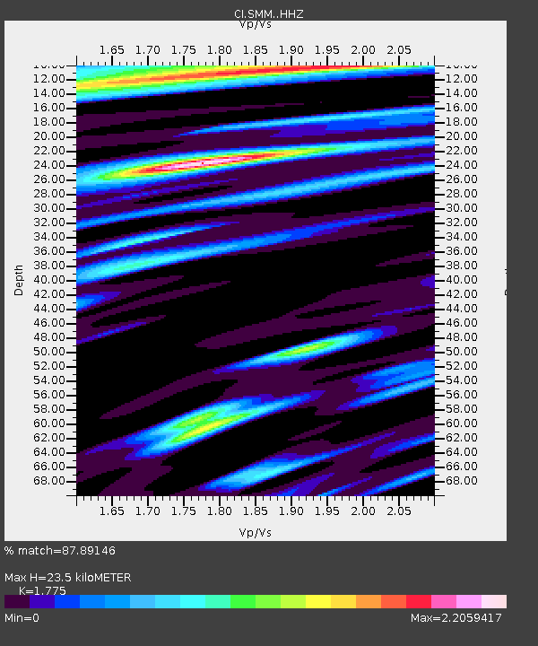
| Estimated Moho Depth: |
23.5 km |
| Estimated Crust Vp/Vs: |
1.77 |
| Assumed Crust Vp: |
6.1 km/s |
| Estimated Crust Vs: |
3.437 km/s |
| Estimated Crust Poisson's Ratio: |
0.27 |
|
| Radial Match: |
87.89146 % |
| Radial Bump: |
400 |
| Transverse Match: |
77.31006 % |
| Transverse Bump: |
400 |
| SOD ConfigId: |
11737051 |
| Insert Time: |
2019-04-27 08:51:59.817 +0000 |
| GWidth: |
2.5 |
| Max Bumps: |
400 |
| Tol: |
0.001 |
|
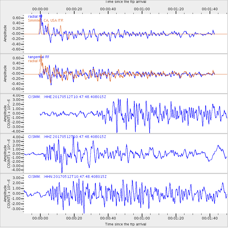
Signal To Noise
| Channel | StoN | STA | LTA |
| CI:SMM: :HHZ:20170512T10:47:48.408015Z | 4.2804985 | 6.706229E-7 | 1.5666934E-7 |
| CI:SMM: :HHN:20170512T10:47:48.408015Z | 0.99313337 | 3.6859308E-7 | 3.7114157E-7 |
| CI:SMM: :HHE:20170512T10:47:48.408015Z | 1.1738613 | 3.075289E-7 | 2.619806E-7 |
| Arrivals |
| Ps | 3.2 SECOND |
| PpPs | 10.0 SECOND |
| PsPs/PpSs | 13 SECOND |


