You are here: Home > Network List > GS - US Geological Survey Networks Stations List
> Station DEC07 Decatur Surface Seismic Site, Decatur, IL, USA > Earthquake Result Viewer
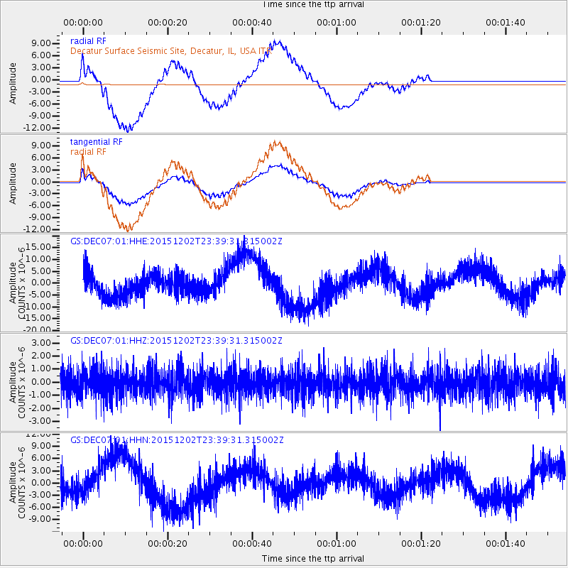
DEC07 Decatur Surface Seismic Site, Decatur, IL, USA - Earthquake Result Viewer
*The percent match for this event was below the threshold and hence no stack was calculated.
| Earthquake location: |
Turkey |
| Earthquake latitude/longitude: |
39.2/40.3 |
| Earthquake time(UTC): |
2015/12/02 (336) 23:27:09 GMT |
| Earthquake Depth: |
6.3 km |
| Earthquake Magnitude: |
5.5 MB |
| Earthquake Catalog/Contributor: |
NEIC PDE/NEIC COMCAT |
|
| Network: |
GS US Geological Survey Networks |
| Station: |
DEC07 Decatur Surface Seismic Site, Decatur, IL, USA |
| Lat/Lon: |
39.86 N/88.90 W |
| Elevation: |
212 m |
|
| Distance: |
88.6 deg |
| Az: |
323.348 deg |
| Baz: |
37.045 deg |
| Ray Param: |
$rayparam |
*The percent match for this event was below the threshold and hence was not used in the summary stack. |
|
| Radial Match: |
74.8175 % |
| Radial Bump: |
400 |
| Transverse Match: |
78.27982 % |
| Transverse Bump: |
400 |
| SOD ConfigId: |
1259291 |
| Insert Time: |
2015-12-16 23:44:31.845 +0000 |
| GWidth: |
2.5 |
| Max Bumps: |
400 |
| Tol: |
0.001 |
|
Signal To Noise
| Channel | StoN | STA | LTA |
| GS:DEC07:01:HHZ:20151202T23:39:31.315002Z | 1.0579152 | 1.0556842E-6 | 9.978911E-7 |
| GS:DEC07:01:HHN:20151202T23:39:31.315002Z | 1.1242774 | 3.2134465E-6 | 2.8582326E-6 |
| GS:DEC07:01:HHE:20151202T23:39:31.315002Z | 1.1164683 | 5.274132E-6 | 4.7239423E-6 |
| Arrivals |
| Ps | |
| PpPs | |
| PsPs/PpSs | |


