You are here: Home > Network List > TA - USArray Transportable Network (new EarthScope stations) Stations List
> Station Z32A Haskell, TX, USA > Earthquake Result Viewer
Z32A Haskell, TX, USA - Earthquake Result Viewer
| Earthquake location: |
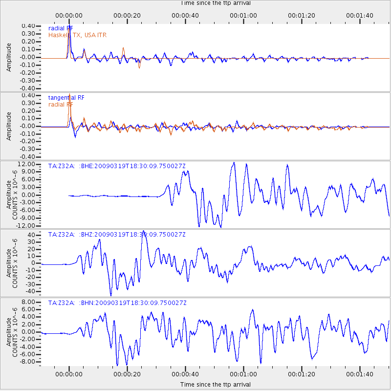
Tonga Islands Region |
| Earthquake latitude/longitude: |
-23.0/-174.7 |
| Earthquake time(UTC): |
2009/03/19 (078) 18:17:40 GMT |
| Earthquake Depth: |
34 km |
| Earthquake Magnitude: |
7.0 MB, 7.6 MS, 7.6 MW, 7.6 MW |
| Earthquake Catalog/Contributor: |
WHDF/NEIC |
|
| Network: |
TA USArray Transportable Network (new EarthScope stations) |
| Station: |
Z32A Haskell, TX, USA |
| Lat/Lon: |
33.31 N/99.48 W |
| Elevation: |
427 m |
|
| Distance: |
90.9 deg |
| Az: |
54.064 deg |
| Baz: |
242.949 deg |
| Ray Param: |
0.041637354 |
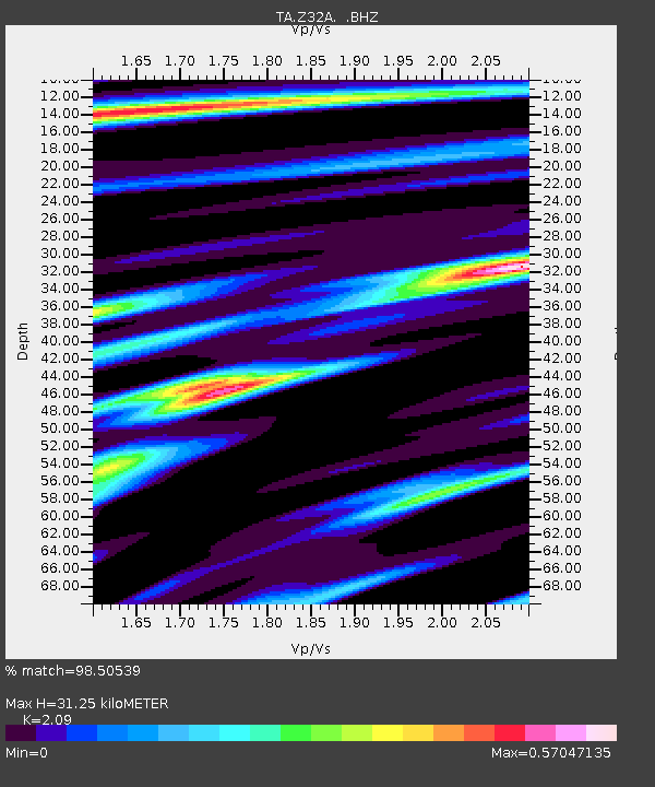
| Estimated Moho Depth: |
31.25 km |
| Estimated Crust Vp/Vs: |
2.09 |
| Assumed Crust Vp: |
6.426 km/s |
| Estimated Crust Vs: |
3.075 km/s |
| Estimated Crust Poisson's Ratio: |
0.35 |
|
| Radial Match: |
98.50539 % |
| Radial Bump: |
316 |
| Transverse Match: |
95.49653 % |
| Transverse Bump: |
400 |
| SOD ConfigId: |
2658 |
| Insert Time: |
2010-03-05 23:50:13.304 +0000 |
| GWidth: |
2.5 |
| Max Bumps: |
400 |
| Tol: |
0.001 |
|
Signal To Noise
| Channel | StoN | STA | LTA |
| TA:Z32A: :BHZ:20090319T18:30:09.750027Z | 20.054066 | 5.944461E-6 | 2.9642172E-7 |
| TA:Z32A: :BHN:20090319T18:30:09.750027Z | 4.585933 | 6.111251E-7 | 1.3326078E-7 |
| TA:Z32A: :BHE:20090319T18:30:09.750027Z | 11.99354 | 1.8006338E-6 | 1.5013364E-7 |
| Arrivals |
| Ps | 5.4 SECOND |
| PpPs | 15 SECOND |
| PsPs/PpSs | 20 SECOND |


