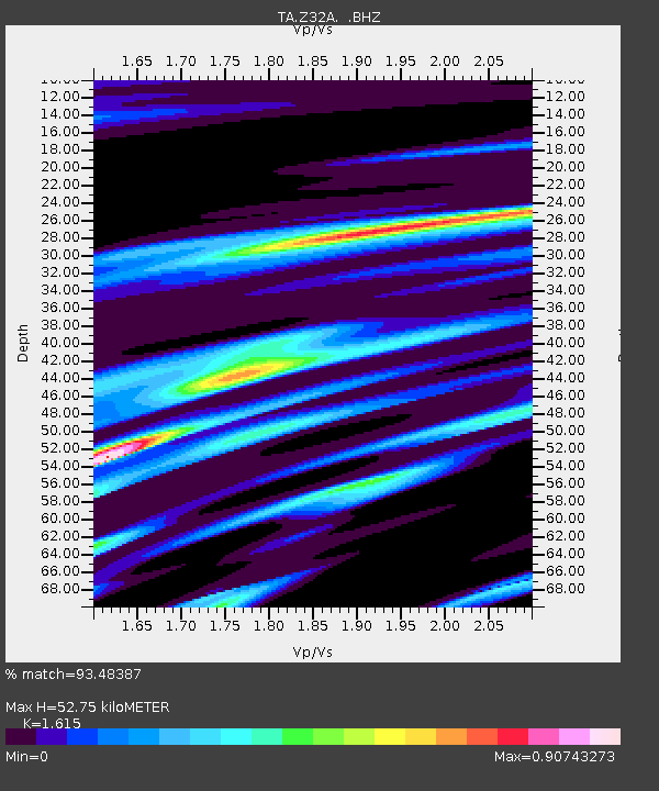
Z32A Haskell, TX, USA - Earthquake Result Viewer

Earthquake location: Rat Islands, Aleutian Islands
Earthquake latitude/longitude: 50.4/177.0
Earthquake time(UTC): 2009/07/06 (187) 14:53:12 GMT
Earthquake Depth: 22 km
Earthquake Magnitude: 6.0 MB, 5.8 MS, 6.1 MW, 6.0 MW
Earthquake Catalog/Contributor: WHDF/NEIC
Network: TA USArray Transportable Network (new EarthScope stations)
Station: Z32A Haskell, TX, USA
Lat/Lon: 33.31 N/99.48 W
Elevation: 427 m
Distance: 61.3 deg
Az: 71.59 deg
Baz: 313.568 deg
Ray Param: 0.060947914
Estimated Moho Depth: 52.75 km
Estimated Crust Vp/Vs: 1.62
Assumed Crust Vp: 6.426 km/s
Estimated Crust Vs: 3.979 km/s
Estimated Crust Poisson's Ratio: 0.19
Radial Match: 93.48387 %
Radial Bump: 343
Transverse Match: 87.11079 %
Transverse Bump: 400
SOD ConfigId: 2648
Insert Time: 2010-03-05 23:50:15.669 +0000
GWidth: 2.5
Max Bumps: 400
Tol: 0.001

Signal To Noise

ChannelStoNSTALTA
TA:Z32A: :BHZ:20090706T15:02:54.75001Z13.1725022.4025217E-61.8238917E-7
TA:Z32A: :BHN:20090706T15:02:54.75001Z10.3524821.3376767E-61.2921315E-7
TA:Z32A: :BHE:20090706T15:02:54.75001Z5.8283481.0782934E-61.8500842E-7
Arrivals
Ps5.3 SECOND
PpPs20 SECOND
PsPs/PpSs26 SECOND