You are here: Home > Network List > TA - USArray Transportable Network (new EarthScope stations) Stations List
> Station Z32A Haskell, TX, USA > Earthquake Result Viewer
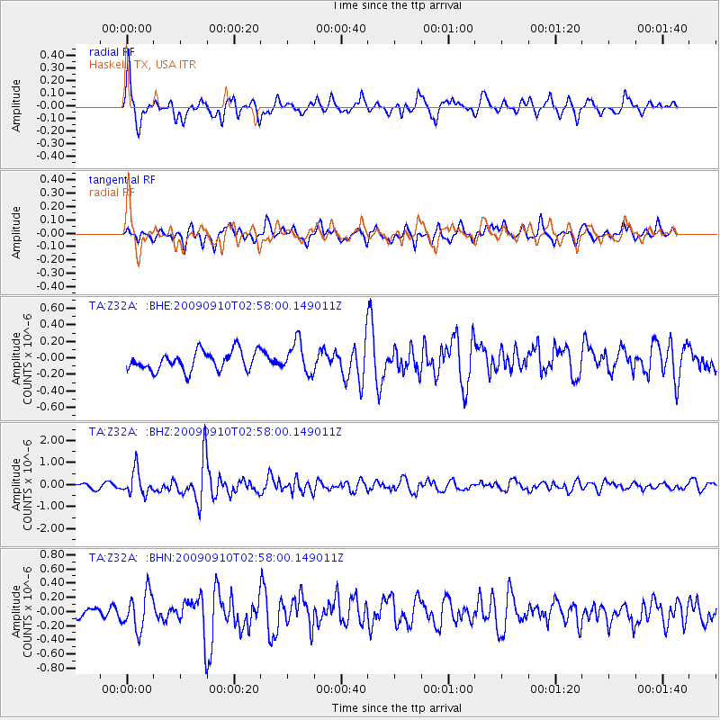
Z32A Haskell, TX, USA - Earthquake Result Viewer
*The percent match for this event was below the threshold and hence no stack was calculated.
| Earthquake location: |
Kuril Islands |
| Earthquake latitude/longitude: |
48.3/154.2 |
| Earthquake time(UTC): |
2009/09/10 (253) 02:46:50 GMT |
| Earthquake Depth: |
36 km |
| Earthquake Magnitude: |
6.0 MB, 5.5 MS, 6.0 MW, 5.8 MW |
| Earthquake Catalog/Contributor: |
WHDF/NEIC |
|
| Network: |
TA USArray Transportable Network (new EarthScope stations) |
| Station: |
Z32A Haskell, TX, USA |
| Lat/Lon: |
33.31 N/99.48 W |
| Elevation: |
427 m |
|
| Distance: |
75.5 deg |
| Az: |
56.095 deg |
| Baz: |
318.582 deg |
| Ray Param: |
$rayparam |
*The percent match for this event was below the threshold and hence was not used in the summary stack. |
|
| Radial Match: |
73.33471 % |
| Radial Bump: |
400 |
| Transverse Match: |
74.22271 % |
| Transverse Bump: |
400 |
| SOD ConfigId: |
2622 |
| Insert Time: |
2010-03-05 23:50:29.341 +0000 |
| GWidth: |
2.5 |
| Max Bumps: |
400 |
| Tol: |
0.001 |
|
Signal To Noise
| Channel | StoN | STA | LTA |
| TA:Z32A: :BHZ:20090910T02:58:00.149011Z | 5.4649806 | 5.5656477E-7 | 1.0184204E-7 |
| TA:Z32A: :BHN:20090910T02:58:00.149011Z | 2.7868721 | 2.6658472E-7 | 9.565731E-8 |
| TA:Z32A: :BHE:20090910T02:58:00.149011Z | 1.6435618 | 1.9044592E-7 | 1.1587389E-7 |
| Arrivals |
| Ps | |
| PpPs | |
| PsPs/PpSs | |


