You are here: Home > Network List > N4 - Central and EAstern US Network Stations List
> Station I37B Waseca, MN, USA > Earthquake Result Viewer
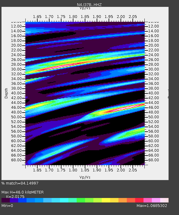
I37B Waseca, MN, USA - Earthquake Result Viewer
| Earthquake location: |
Off Coast Of Central America |
| Earthquake latitude/longitude: |
12.9/-90.1 |
| Earthquake time(UTC): |
2017/05/12 (132) 10:41:26 GMT |
| Earthquake Depth: |
10 km |
| Earthquake Magnitude: |
6.2 Mww |
| Earthquake Catalog/Contributor: |
NEIC PDE/us |
|
| Network: |
N4 Central and EAstern US Network |
| Station: |
I37B Waseca, MN, USA |
| Lat/Lon: |
44.01 N/93.40 W |
| Elevation: |
354 m |
|
| Distance: |
31.1 deg |
| Az: |
355.33 deg |
| Baz: |
173.683 deg |
| Ray Param: |
0.07915069 |
| Estimated Moho Depth: |
46.0 km |
| Estimated Crust Vp/Vs: |
2.02 |
| Assumed Crust Vp: |
6.571 km/s |
| Estimated Crust Vs: |
3.257 km/s |
| Estimated Crust Poisson's Ratio: |
0.34 |
|
| Radial Match: |
84.14997 % |
| Radial Bump: |
400 |
| Transverse Match: |
66.422 % |
| Transverse Bump: |
400 |
| SOD ConfigId: |
11737051 |
| Insert Time: |
2019-04-27 08:55:02.323 +0000 |
| GWidth: |
2.5 |
| Max Bumps: |
400 |
| Tol: |
0.001 |
|

Signal To Noise
| Channel | StoN | STA | LTA |
| N4:I37B: :HHZ:20170512T10:47:14.36999Z | 11.339966 | 1.6785598E-6 | 1.480216E-7 |
| N4:I37B: :HHN:20170512T10:47:14.36999Z | 5.7378225 | 1.0928322E-6 | 1.9046115E-7 |
| N4:I37B: :HHE:20170512T10:47:14.36999Z | 3.511833 | 4.7863506E-7 | 1.3629209E-7 |
| Arrivals |
| Ps | 7.7 SECOND |
| PpPs | 20 SECOND |
| PsPs/PpSs | 27 SECOND |


