You are here: Home > Network List > TA - USArray Transportable Network (new EarthScope stations) Stations List
> Station D23K Nanushuk River, AK USA > Earthquake Result Viewer
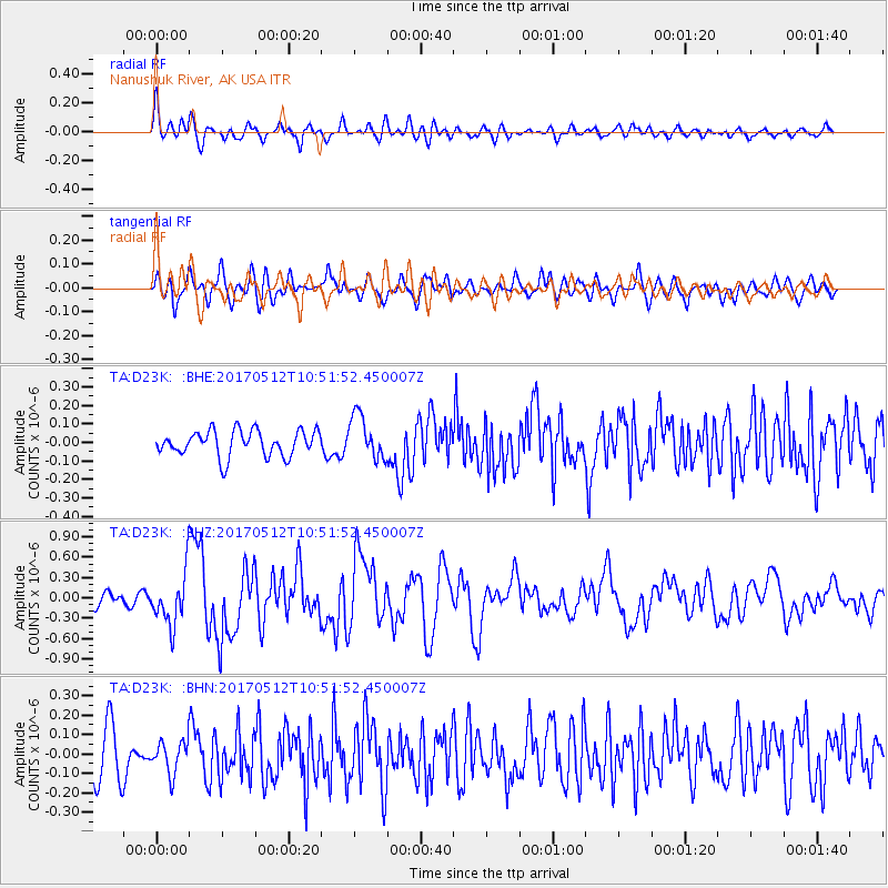
D23K Nanushuk River, AK USA - Earthquake Result Viewer
*The percent match for this event was below the threshold and hence no stack was calculated.
| Earthquake location: |
Off Coast Of Central America |
| Earthquake latitude/longitude: |
12.9/-90.1 |
| Earthquake time(UTC): |
2017/05/12 (132) 10:41:26 GMT |
| Earthquake Depth: |
10 km |
| Earthquake Magnitude: |
6.2 Mww |
| Earthquake Catalog/Contributor: |
NEIC PDE/us |
|
| Network: |
TA USArray Transportable Network (new EarthScope stations) |
| Station: |
D23K Nanushuk River, AK USA |
| Lat/Lon: |
68.97 N/150.68 W |
| Elevation: |
406 m |
|
| Distance: |
67.7 deg |
| Az: |
340.118 deg |
| Baz: |
113.297 deg |
| Ray Param: |
$rayparam |
*The percent match for this event was below the threshold and hence was not used in the summary stack. |
|
| Radial Match: |
74.89914 % |
| Radial Bump: |
400 |
| Transverse Match: |
63.75527 % |
| Transverse Bump: |
400 |
| SOD ConfigId: |
11737051 |
| Insert Time: |
2019-04-27 08:57:39.658 +0000 |
| GWidth: |
2.5 |
| Max Bumps: |
400 |
| Tol: |
0.001 |
|
Signal To Noise
| Channel | StoN | STA | LTA |
| TA:D23K: :BHZ:20170512T10:51:52.450007Z | 3.546543 | 3.8319052E-7 | 1.08046216E-7 |
| TA:D23K: :BHN:20170512T10:51:52.450007Z | 0.67838365 | 8.339928E-8 | 1.2293822E-7 |
| TA:D23K: :BHE:20170512T10:51:52.450007Z | 1.7115808 | 1.1794258E-7 | 6.890857E-8 |
| Arrivals |
| Ps | |
| PpPs | |
| PsPs/PpSs | |


