You are here: Home > Network List > TA - USArray Transportable Network (new EarthScope stations) Stations List
> Station F21K Alatna River, AK, USA > Earthquake Result Viewer
F21K Alatna River, AK, USA - Earthquake Result Viewer
| Earthquake location: |
Off Coast Of Central America |
| Earthquake latitude/longitude: |
12.9/-90.1 |
| Earthquake time(UTC): |
2017/05/12 (132) 10:41:26 GMT |
| Earthquake Depth: |
10 km |
| Earthquake Magnitude: |
6.2 Mww |
| Earthquake Catalog/Contributor: |
NEIC PDE/us |
|
| Network: |
TA USArray Transportable Network (new EarthScope stations) |
| Station: |
F21K Alatna River, AK, USA |
| Lat/Lon: |
67.22 N/153.48 W |
| Elevation: |
597 m |
|
| Distance: |
68.0 deg |
| Az: |
337.942 deg |
| Baz: |
109.879 deg |
| Ray Param: |
0.05657884 |
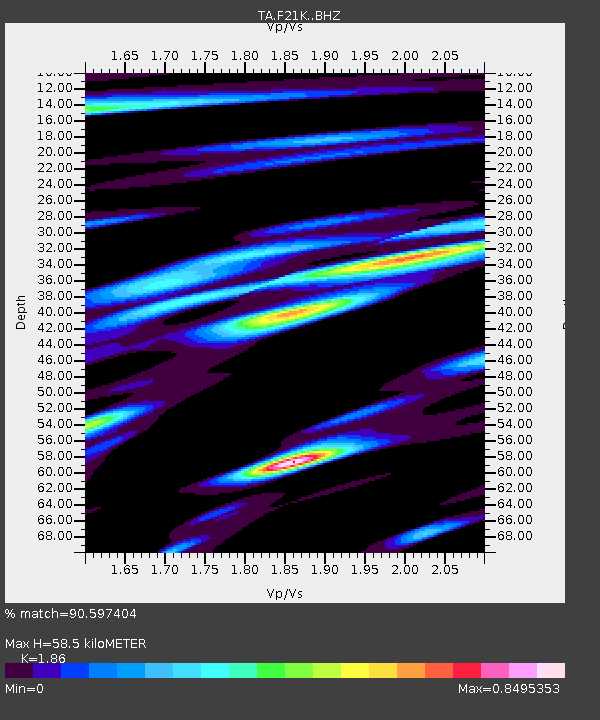
| Estimated Moho Depth: |
58.5 km |
| Estimated Crust Vp/Vs: |
1.86 |
| Assumed Crust Vp: |
6.455 km/s |
| Estimated Crust Vs: |
3.471 km/s |
| Estimated Crust Poisson's Ratio: |
0.30 |
|
| Radial Match: |
90.597404 % |
| Radial Bump: |
400 |
| Transverse Match: |
79.64086 % |
| Transverse Bump: |
400 |
| SOD ConfigId: |
11737051 |
| Insert Time: |
2019-04-27 08:57:46.743 +0000 |
| GWidth: |
2.5 |
| Max Bumps: |
400 |
| Tol: |
0.001 |
|
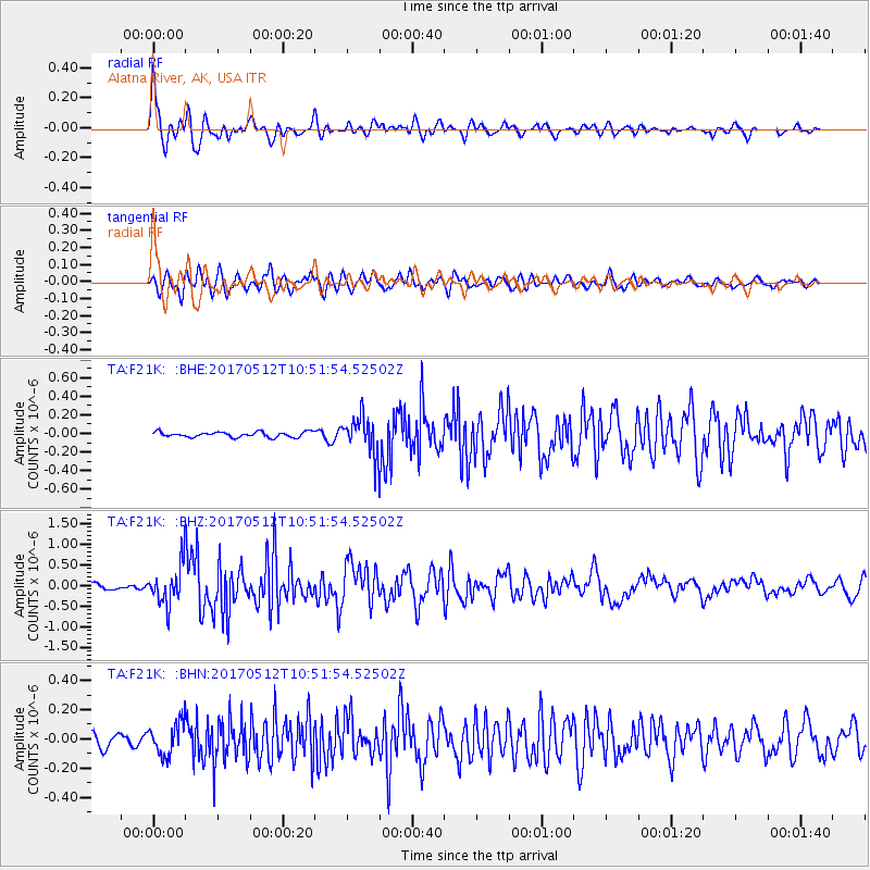
Signal To Noise
| Channel | StoN | STA | LTA |
| TA:F21K: :BHZ:20170512T10:51:54.52502Z | 7.099142 | 4.739063E-7 | 6.675543E-8 |
| TA:F21K: :BHN:20170512T10:51:54.52502Z | 2.1300852 | 1.1101106E-7 | 5.2115784E-8 |
| TA:F21K: :BHE:20170512T10:51:54.52502Z | 7.0248847 | 1.9582487E-7 | 2.7875881E-8 |
| Arrivals |
| Ps | 8.1 SECOND |
| PpPs | 25 SECOND |
| PsPs/PpSs | 33 SECOND |


